Approximate Location Map
Large Map »
Latitude: 50.1917 / 50°11'30"N
Longitude: -5.5675 / 5°34'2"W
OS Eastings: 145466
OS Northings: 38501
OS Grid: SW454385
Mapcode National: GBR DXM5.JLL
Mapcode Global: VH053.GF2W
Plus Code: 9C2P5CRM+M2
Entry Name: Cross at Approximately 5 Metres South of Tower of Church of St Sennar
Listing Date: 7 September 1988
Grade: II
Source: Historic England
Source ID: 1312063
English Heritage Legacy ID: 70650
ID on this website: 101312063
Location: St Sennara's Church, Zennor, Cornwall, TR26
County: Cornwall
Civil Parish: Zennor
Traditional County: Cornwall
Lieutenancy Area (Ceremonial County): Cornwall
Church of England Parish: Zennor
Church of England Diocese: Truro
Tagged with: Wayside cross
ZENNOR ZENNOR
SW 43 NE
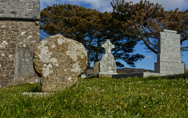
4/331 Cross at approximately 5 metres
- south of tower of Church of St
Sennar
GV II
Cross. Medieval. Granite monolith with wheel head. Relief carving to each face.
East face has Greek cross, west face has Latin cross.
Listing NGR: SW4546638501
External links are from the relevant listing authority and, where applicable, Wikidata. Wikidata IDs may be related buildings as well as this specific building. If you want to add or update a link, you will need to do so by editing the Wikidata entry.


Other nearby listed buildings
