Latitude: 54.8501 / 54°51'0"N
Longitude: -3.0285 / 3°1'42"W
OS Eastings: 334060
OS Northings: 551070
OS Grid: NY340510
Mapcode National: GBR 7D9C.45
Mapcode Global: WH807.GC26
Plus Code: 9C6RVX2C+2J
Entry Name: Milestone South of Nealhouse Farm
Listing Date: 8 November 1984
Grade: II
Source: Historic England
Source ID: 1312456
English Heritage Legacy ID: 71943
ID on this website: 101312456
Location: Nealhouse, Cumberland, Cumbria, CA5
County: Cumberland
District: Allerdale
Civil Parish: Thursby
Traditional County: Cumberland
Lieutenancy Area (Ceremonial County): Cumbria
Church of England Parish: Thursby St Andrew
Church of England Diocese: Carlisle
Tagged with: Milestone
NY 35 SW THURSBY Nealhouse
10/65 Milestone south of Nealhouse Farm II
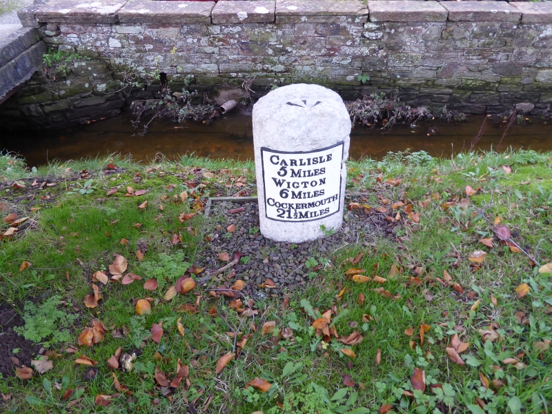
Milestone. Late C18 or early C19 for the Carlisle-Cockermouth Turnpike. Red sandstone, cast-iron plate. Rounded-top stone with curved face, plate to front with raised letters CARLISLE 5 MILES, WIGTON 6 MILES, COCKERMOUTH 21½ MILES. Whitewashed with lettering picked out in black. O.S. bench mark on top of stone.
Listing NGR: NY3406051070
External links are from the relevant listing authority and, where applicable, Wikidata. Wikidata IDs may be related buildings as well as this specific building. If you want to add or update a link, you will need to do so by editing the Wikidata entry.


Other nearby listed buildings