Latitude: 51.5832 / 51°34'59"N
Longitude: -2.5765 / 2°34'35"W
OS Eastings: 360152
OS Northings: 187308
OS Grid: ST601873
Mapcode National: GBR JR.CGM4
Mapcode Global: VH882.9G8N
Plus Code: 9C3VHCMF+7C
Entry Name: The Old Vicarage
Listing Date: 21 October 1952
Last Amended: 5 December 1984
Grade: II
Source: Historic England
Source ID: 1312467
English Heritage Legacy ID: 35331
ID on this website: 101312467
Location: Olveston, South Gloucestershire, BS35
County: South Gloucestershire
Civil Parish: Olveston
Built-Up Area: Olveston
Traditional County: Gloucestershire
Lieutenancy Area (Ceremonial County): Gloucestershire
Church of England Parish: Olveston
Church of England Diocese: Bristol
Tagged with: Clergy house
ST 68 NW OLVESTON VICARAGE LANE (north side)
Olveston
8/226
21.10.52 The Old Vicarage (formerly
G.V. listed as Vicarage)
II
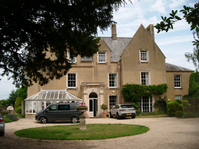
Vicarage, now 2 houses. C17 origin, with C18 and C19 alterations and
additions, with later alterations. Rubble, stone dressings, rendered, slate
roof with raised coped verges and irregular stacks including external stack to
front. 2½ storeys including gabled projecting wing to right, 2:1 windows, all
sashes in moulded architrave with keystone and cill on brackets, 2 dormer gables
to left, central porch has round headed opening with impost blocks, pilasters,
cornice on brackets, parapet and coping, side light of 10-panes to right, inner
panelled and fielded door with transom light, C20 door and C20 conservatory to
left, panelled and glass door with margin glazing; lower 2-storey wing to right
has one window, lst floor sash in plain reveal, ground floor C20 window and
door. West elevation in 3 parts has lower 2-storey block to left, central
block stepped up to main block to right, 1:1:2 windows, left block has sash at
ground and 1st floor, plank door to right, central block has sash at ground and
1st floor, main block has canted bay through 2 storeys to right with 3 sashes at
each level, sash to 1st floor and ground floor left, with side lights at ground
floor, all in surround as on front, ground floor sashes rising from ground
level, dormer gable and gable, each with sash, left and centre blocks have
parapet and cornice. Attached wall to north has plank and fillet door with
4-centred arched head in chamfered stone surround. East elevation of 2 storeys
and 3 windows, all varied, including ground floor left Cl7 6-light casement with
loop catch, leaded lights to some openings, iron stanchions. Interior: not
accessible. Part of an important group at a crossroads.
Listing NGR: ST6015287308
External links are from the relevant listing authority and, where applicable, Wikidata. Wikidata IDs may be related buildings as well as this specific building. If you want to add or update a link, you will need to do so by editing the Wikidata entry.


Other nearby listed buildings