Latitude: 50.2109 / 50°12'39"N
Longitude: -5.4793 / 5°28'45"W
OS Eastings: 151860
OS Northings: 40335
OS Grid: SW518403
Mapcode National: GBR DXV4.2YN
Mapcode Global: VH12D.ZY6Q
Plus Code: 9C2P6G6C+97
Entry Name: 4, the Terrace
Listing Date: 22 December 1972
Grade: II
Source: Historic England
Source ID: 1312555
English Heritage Legacy ID: 69115
ID on this website: 101312555
Location: St Ives, Cornwall, TR26
County: Cornwall
Civil Parish: St. Ives
Built-Up Area: St Ives
Traditional County: Cornwall
Lieutenancy Area (Ceremonial County): Cornwall
Church of England Parish: St Ives
Church of England Diocese: Truro
Tagged with: Building
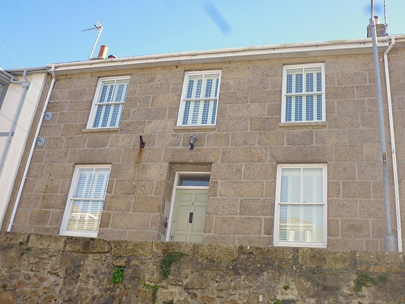
THE TERRACE
1. -----------
1587 No 4
SW 54 SW 1/156
II GV
2.
Early C19. Granite ashlar, Two storeys. Three sash windows, no glazing
bars. Central pirielled door, plain rectangular fanlight. Slate roof.
Group value.
Nos 1 to 4 (consec) form a group.
Listing NGR: SW5186040335
External links are from the relevant listing authority and, where applicable, Wikidata. Wikidata IDs may be related buildings as well as this specific building. If you want to add or update a link, you will need to do so by editing the Wikidata entry.


Other nearby listed buildings