Approximate Location Map
Large Map »
Latitude: 50.2157 / 50°12'56"N
Longitude: -5.4796 / 5°28'46"W
OS Eastings: 151858
OS Northings: 40869
OS Grid: SW518408
Mapcode National: GBR DXV3.NTD
Mapcode Global: VH12D.ZV01
Plus Code: 9C2P6G8C+74
Entry Name: Norway Stores
Listing Date: 22 December 1972
Grade: II
Source: Historic England
Source ID: 1312563
English Heritage Legacy ID: 69066
ID on this website: 101312563
Location: St Ives, Cornwall, TR26
County: Cornwall
Civil Parish: St. Ives
Built-Up Area: St Ives
Traditional County: Cornwall
Lieutenancy Area (Ceremonial County): Cornwall
Church of England Parish: St Ives
Church of England Diocese: Truro
Tagged with: Building
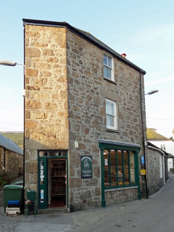
NORWAY LANE
1. -----------
1587 Nos 1, 2 and 3
SW 54 SW 1/116
II
2.
Includes Norway Stores, Back Road. Earlier C19. Granite rubble, slate
hung above ground floor. Three storeys, five windows overall, sashes in
mounlded cases, no glazing bars. Modern glazed doors. North end onto Back
Road has C19 shop window of five lights, fluted Ionic pilasters. Slurried
slate hipped roof.
Listing NGR: SW5185840869
External links are from the relevant listing authority and, where applicable, Wikidata. Wikidata IDs may be related buildings as well as this specific building. If you want to add or update a link, you will need to do so by editing the Wikidata entry.


Other nearby listed buildings
