Approximate Location Map
Large Map »
Latitude: 53.8808 / 53°52'50"N
Longitude: -1.3495 / 1°20'58"W
OS Eastings: 442857
OS Northings: 442933
OS Grid: SE428429
Mapcode National: GBR MR0K.MK
Mapcode Global: WHDB7.7QM7
Plus Code: 9C5WVMJ2+85
Entry Name: Old Malt Kiln
Listing Date: 3 December 1986
Grade: II
Source: Historic England
Source ID: 1313178
English Heritage Legacy ID: 342207
ID on this website: 101313178
Location: Bramham, Leeds, West Yorkshire, LS23
County: Leeds
Civil Parish: Bramham cum Oglethorpe
Built-Up Area: Bramham
Traditional County: Yorkshire
Lieutenancy Area (Ceremonial County): West Yorkshire
Church of England Parish: Lower Wharfe
Church of England Diocese: York
Tagged with: Architectural structure
BRAMHAM CUM OGLETHORPE HIGH STREET
SE44SW
LS23 (north side)
1/46 Old Malt Kiln
II
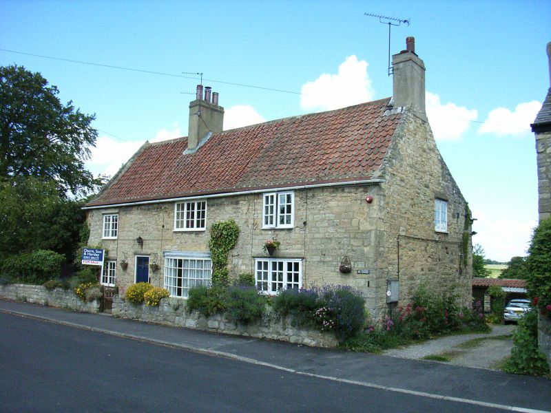
Farmhouse, now house. Probably early C17, altered and cased in stone in C18;
altered. Coursed magnesian limestone rubble, pantiled roof with corrugated
sheet eaves, but incorporating remains of former timber-framed structure.
Linear 3-cell lobby-entry plan, with continuous rear outshut. Two storeys.
Quoins. Glazed door at junction of 1st and 2nd cells, a 2-light casement to
the left, an inserted modern bow window and a 3-light casement to the right,
and casements of 2, 3,and 2 lights at lst floor. Steeply-pitched roof with
gable parapet at left end, chimney on ridge in line with door and at right
gable. Left gable has one window at ground floor, another at upper level of
outshut; right gable has window at 1st floor; rear altered and of less interest.
Interior: evidence of former timber-framed structure includes one wall post
in front wall (at junction of 2nd and 3rd bays), and 3 in screen wall to outshut
with a wallplate, and pegholes in this for longitudinal bracing to the posts
and towards the present stone gable wall at the left end; some evidence that
roof was formerly hipped at this end; inglenook fireplace with remains of former
smoke hood on opposite side of stack at 1st floor; chamfered firehood bressummer
in 2nd bay, another in 3rd bay; lateral partition between 2nd and 3rd bays
removed (wattle holes for it in beam); "beehive" breadoven in rear of stack,
now concealed.
Listing NGR: SE4285742933
External links are from the relevant listing authority and, where applicable, Wikidata. Wikidata IDs may be related buildings as well as this specific building. If you want to add or update a link, you will need to do so by editing the Wikidata entry.


Other nearby listed buildings
