Approximate Location Map
Large Map »
Latitude: 53.4835 / 53°29'0"N
Longitude: -1.2303 / 1°13'48"W
OS Eastings: 451175
OS Northings: 398809
OS Grid: SK511988
Mapcode National: GBR MXV4.FZ
Mapcode Global: WHDD7.2PFT
Plus Code: 9C5WFQM9+CV
Entry Name: Well Cover Approximately 50 Metres North West of Junction with Church Street
Listing Date: 5 November 1962
Last Amended: 26 November 1987
Grade: II
Source: Historic England
Source ID: 1314842
English Heritage Legacy ID: 334807
ID on this website: 101314842
Location: Conisbrough, Doncaster, South Yorkshire, DN12
County: Doncaster
Electoral Ward/Division: Conisbrough
Parish: Non Civil Parish
Built-Up Area: Conisbrough
Traditional County: Yorkshire
Lieutenancy Area (Ceremonial County): South Yorkshire
Church of England Parish: Conisbrough St Peter
Church of England Diocese: Sheffield
Tagged with: Well
CONISBROUGH WELLGATEE
SK59NW (east side)
4/34 Well cover
5.ll.b2 approximately 50 metres
north-west of junction
with Church Street
(formerly listed as The
Yells Head)
II
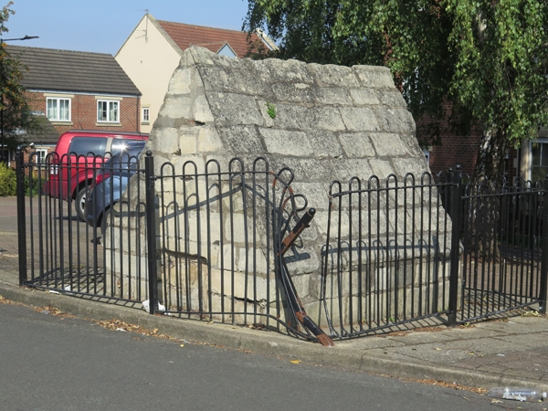
Well cover. Late medieval. Ashlar limestone. Small rectangular building,
now partly buried in pavement . South end facing road has blocked rebated
opening at pavement level; ashlar stones, worked to the pitch of the roof,
have verge projection and roll-mould to ridge. Unique survival in the
Doncaster district.
Listing NGR: SK5119698797
External links are from the relevant listing authority and, where applicable, Wikidata. Wikidata IDs may be related buildings as well as this specific building. If you want to add or update a link, you will need to do so by editing the Wikidata entry.


Other nearby listed buildings
