Approximate Location Map
Large Map »
Latitude: 53.9636 / 53°57'48"N
Longitude: -2.735 / 2°44'5"W
OS Eastings: 351875
OS Northings: 452195
OS Grid: SD518521
Mapcode National: GBR 9QBL.PX
Mapcode Global: WH84M.YMST
Plus Code: 9C5VX778+C2
Entry Name: Street Bridge
Listing Date: 9 January 1986
Grade: II
Source: Historic England
Source ID: 1318033
English Heritage Legacy ID: 185558
ID on this website: 101318033
Location: Street, Wyre, Lancashire, LA2
County: Lancashire
District: Wyre
Civil Parish: Nether Wyresdale
Traditional County: Lancashire
Lieutenancy Area (Ceremonial County): Lancashire
Church of England Parish: Barnacre All Saints
Church of England Diocese: Blackburn
Tagged with: Bridge
NETHER WYRESDALE
SD 55 SW
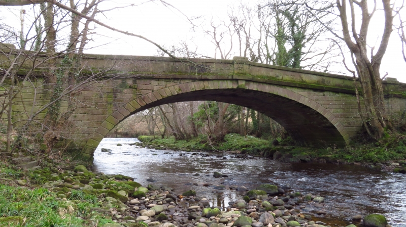
2/164 Street Bridge
-
- II
Bridge over River Wyre, 1835. Punched sandstone blocks with chamfered
rustication. Single elliptical arch with keystone. Band below solid
parapet with coping. Above the keystone on the west side is inscribed
within a border: 'JT 1835'.
Listing NGR: SD5187552195
External links are from the relevant listing authority and, where applicable, Wikidata. Wikidata IDs may be related buildings as well as this specific building. If you want to add or update a link, you will need to do so by editing the Wikidata entry.


Other nearby listed buildings
