Approximate Location Map
Large Map »
Latitude: 51.3717 / 51°22'18"N
Longitude: -0.9674 / 0°58'2"W
OS Eastings: 471976
OS Northings: 164131
OS Grid: SU719641
Mapcode National: GBR C6M.VN9
Mapcode Global: VHDX6.5SYB
Plus Code: 9C3X92CM+M3
Entry Name: Barn Adjacent to Goddard's Farmhouse on the North
Listing Date: 14 February 1986
Grade: II
Source: Historic England
Source ID: 1319146
English Heritage Legacy ID: 41572
ID on this website: 101319146
Location: Swallowfield, Wokingham, Berkshire, RG7
County: Wokingham
Civil Parish: Swallowfield
Built-Up Area: Swallowfield
Traditional County: Berkshire
Lieutenancy Area (Ceremonial County): Berkshire
Church of England Parish: Swallowfield
Church of England Diocese: Oxford
Tagged with: Barn
SWALLOWFIELD BASINGSTOKE ROAD
SU 76 SW
(West side) Riseley
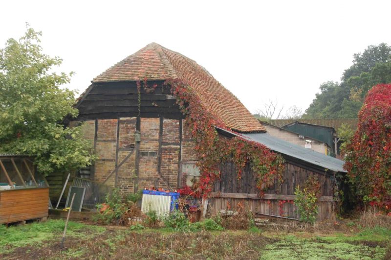
11/6 Barn adjacent to Goddard's
Farmhouse on the north
G.V. II
Small hay barn. C18. Timber framed with brick infill; Half-hipped old
tile roof. Rectangular plan of 2 framed bays. Thin timbers; later floor
in one bay. Included for group value.
Listing NGR: SU7197664131
External links are from the relevant listing authority and, where applicable, Wikidata. Wikidata IDs may be related buildings as well as this specific building. If you want to add or update a link, you will need to do so by editing the Wikidata entry.


Other nearby listed buildings
