Approximate Location Map
Large Map »
Latitude: 51.401 / 51°24'3"N
Longitude: -1.2607 / 1°15'38"W
OS Eastings: 451526
OS Northings: 167149
OS Grid: SU515671
Mapcode National: GBR 93D.03W
Mapcode Global: VHCZL.31DS
Plus Code: 9C3WCP2Q+CP
Entry Name: Granary Approximately 20 Metres to North East of the Grange
Listing Date: 6 April 1967
Grade: II
Source: Historic England
Source ID: 1319522
English Heritage Legacy ID: 39633
ID on this website: 101319522
Location: Thatcham, West Berkshire, RG19
County: West Berkshire
Civil Parish: Thatcham
Built-Up Area: Thatcham
Traditional County: Berkshire
Lieutenancy Area (Ceremonial County): Berkshire
Church of England Parish: Thatcham
Church of England Diocese: Oxford
Tagged with: Granary
THATCHAM CHURCH GATE (south side)
SU 5167
8/30 Granary Approximately 20
6.4.67 Metres To North-East Of
The Grange
GV II
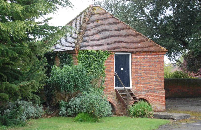
Granary. C18. Red brick and hipped old tile roof with weathervane. Square plan.
One storey resting on low brick arches, 2 each side. Door to west and window to
south. B.O.E.Berkshire. p.240.
Listing NGR: SU5152667149
External links are from the relevant listing authority and, where applicable, Wikidata. Wikidata IDs may be related buildings as well as this specific building. If you want to add or update a link, you will need to do so by editing the Wikidata entry.


Other nearby listed buildings
