Latitude: 51.4002 / 51°24'0"N
Longitude: -1.4473 / 1°26'50"W
OS Eastings: 438542
OS Northings: 166936
OS Grid: SU385669
Mapcode National: GBR 70H.0X9
Mapcode Global: VHC20.V2QG
Plus Code: 9C3WCH23+33
Entry Name: Tudor Cottage
Listing Date: 6 February 1962
Last Amended: 21 June 1984
Grade: II
Source: Historic England
Source ID: 1319543
English Heritage Legacy ID: 39748
ID on this website: 101319543
Location: Kintbury, West Berkshire, RG17
County: West Berkshire
Civil Parish: Kintbury
Built-Up Area: Kintbury
Traditional County: Berkshire
Lieutenancy Area (Ceremonial County): Berkshire
Church of England Parish: Kintbury
Church of England Diocese: Oxford
Tagged with: Cottage
SU 36 NE KINTBURY STATION ROAD (south east side)
12/35 Tudor Cottage (formerly listed as Tudor House) 6.2.62
II
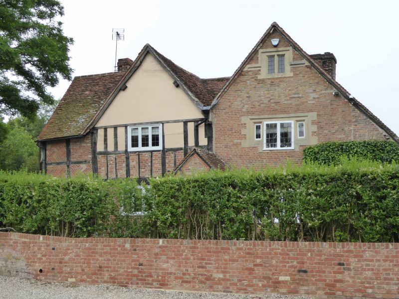
Cottage. C16, 17 with C18 and 19 additions and C20 alterations. Timber frame with brick and some plaster infill, C17 brick and stone dressings, brick, tile hanging and painted render. Tiled hipped and gabled roots. Roughly L shaped plan, the main arm being orientated on a south west/north east axis. The north west face has two gables, the north east face one and the south east face has one central gable and a single storey C20 lean to extension. The other arm has a hip to the south east and a single storey extension on that end. 2 storeys and 2 storeys and attic with 1 storey extensions. Large grouped brick stack on centre of short arm of L, small stack off ridge to north east of main arm. North West Elevation: Timber frame exposed to left hand side; to far left, one bay of 2 square panels with some herringbone brick infill and plain brick infill, 2 light C20 casement on ground floor. To left of centre is a cross gable with bargeboard and rendered gable above timber frame with some brick and some plaster infill on first floor and brick ground floor. One 3 light casement on each floor. To right of centre, C17 brick faced gabled crosswing with 2 light stone mullioned window in apex of gable, with label mould and 4 light stone dressed formerly mullioned window on first floor, now with central lights extended downwards to accommodate 2 light C18 iron leaded casement, C20 four light casement on ground floor in partly blocked stone dressed opening. To far right C18 brick faced outshut with one 2 light leaded casement under catslide; across junction of central gabled wings is large brick and timber C20 gabled porch over entrance door.
Listing NGR: SU3854266936
External links are from the relevant listing authority and, where applicable, Wikidata. Wikidata IDs may be related buildings as well as this specific building. If you want to add or update a link, you will need to do so by editing the Wikidata entry.


Other nearby listed buildings