Approximate Location Map
Large Map »
Latitude: 51.8755 / 51°52'31"N
Longitude: -0.5888 / 0°35'19"W
OS Eastings: 497243
OS Northings: 220604
OS Grid: SP972206
Mapcode National: GBR F3S.7ZM
Mapcode Global: VHFRJ.R421
Plus Code: 9C3XVCG6+6F
Entry Name: Moat Farmhouse
Listing Date: 26 September 1980
Grade: II
Source: Historic England
Source ID: 1321357
English Heritage Legacy ID: 35927
ID on this website: 101321357
Location: Eaton Bray, Central Bedfordshire, LU6
County: Central Bedfordshire
Civil Parish: Eaton Bray
Built-Up Area: Eaton Bray
Traditional County: Bedfordshire
Lieutenancy Area (Ceremonial County): Bedfordshire
Church of England Parish: Eaton Bray with Edlesborough
Church of England Diocese: St.Albans
Tagged with: Farmhouse
1.
5125
SP9720
35/81
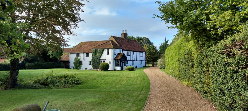
EATON BRAY
HIGH STREET
No 72
(Moat Farmhouse)
II
GV
2.
C17. Timber-framed first floor with whitewashed brick nogging; ground floor plaster
rendered. Two storeys. Old clay tile roof. Three casements. Central brick stack.
C18 west wing of whitewashed brick. Hipped old clay tile roof and modern porch.
Listing NGR: SP9724320604
External links are from the relevant listing authority and, where applicable, Wikidata. Wikidata IDs may be related buildings as well as this specific building. If you want to add or update a link, you will need to do so by editing the Wikidata entry.


Other nearby listed buildings
