Approximate Location Map
Large Map »
Latitude: 51.8857 / 51°53'8"N
Longitude: -0.5222 / 0°31'20"W
OS Eastings: 501803
OS Northings: 221829
OS Grid: TL018218
Mapcode National: GBR G50.LSZ
Mapcode Global: VHFRC.WVSS
Plus Code: 9C3XVFPH+74
Entry Name: 16-20, West Street
Listing Date: 4 March 1976
Grade: II
Source: Historic England
Source ID: 1321361
English Heritage Legacy ID: 35769
ID on this website: 101321361
Location: Dunstable, Central Bedfordshire, LU6
County: Central Bedfordshire
Civil Parish: Dunstable
Built-Up Area: Dunstable
Traditional County: Bedfordshire
Lieutenancy Area (Ceremonial County): Bedfordshire
Church of England Parish: Dunstable
Church of England Diocese: St.Albans
Tagged with: Building
1.
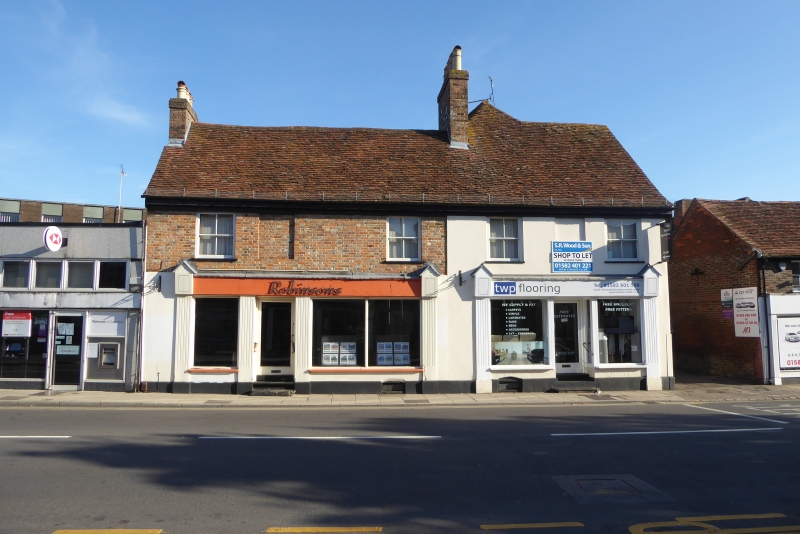
5125 WEST STREET
(North Side)
Nos 16 to 20 (even)
TL 0121 NE 1/30
II GV
2.
Early Cl8 front, altered by insertion of C19 shop fronts. Timber frame, old tiled
roof with wooden eaves cornice. 6 first floor sash windows, Back wing has red
brick mssive chimney stack with 2 round arched panels.
Nos 12 and 14A and Nos 16 to 20 (even) form a group.
Listing NGR: TL0180321829
External links are from the relevant listing authority and, where applicable, Wikidata. Wikidata IDs may be related buildings as well as this specific building. If you want to add or update a link, you will need to do so by editing the Wikidata entry.


Other nearby listed buildings
