Latitude: 52.01 / 52°0'36"N
Longitude: -0.3488 / 0°20'55"W
OS Eastings: 513424
OS Northings: 235907
OS Grid: TL134359
Mapcode National: GBR H50.W28
Mapcode Global: VHFQW.WQYZ
Plus Code: 9C4X2M62+2F
Entry Name: Manor House
Listing Date: 31 October 1966
Grade: II
Source: Historic England
Source ID: 1321779
English Heritage Legacy ID: 37851
ID on this website: 101321779
Location: Central Bedfordshire, SG17
County: Central Bedfordshire
Civil Parish: Meppershall
Built-Up Area: Meppershall
Traditional County: Bedfordshire
Lieutenancy Area (Ceremonial County): Bedfordshire
Church of England Parish: Meppershall
Church of England Diocese: St.Albans
Tagged with: House
TL 13 NW MEPPERSHALL CHURCH ROAD
3/62 31.10.66 Manor House
GV II
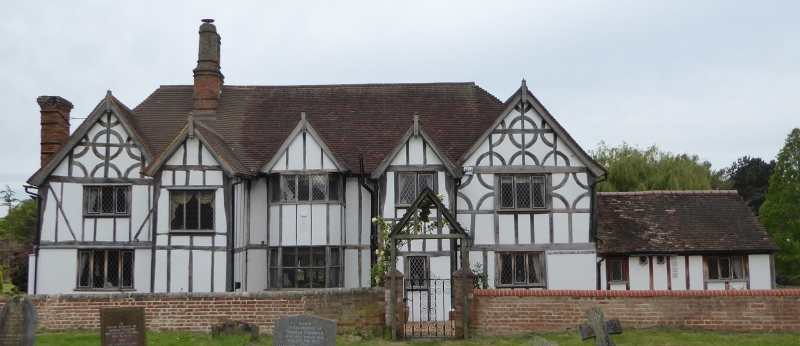
House. Early Cl7. Much of upper part rebuilt after fire in 1959. Timber framed construction, mostly with colourwashed plaster infill, parts of ground floor of cross-wings rebuilt in red brick. Clay tile roofs, that to main block hipped. H-plan, 2 storeys, with C20 dormers to roof of rear elevation. E elevation: 5 2-storeyed gables in all, central one a porch, the 2nd and 4th gables projecting beyond the cross-wings. Casement windows with leaded lights, 3 to ground floor, 5 to first floor. Porch gable has reset pargetting panel with thistle design. Cross-wings have ornamental curved brace decoration to upper part, apparently mostly recent. Main block has red brick double ridge stack with a pair of moulded octagonal shafts. Red brick external stack, rebuilt C20, to side wall of LH cross-wing. Single storeyed addition adjoins to N.
Listing NGR: TL1342435907
External links are from the relevant listing authority and, where applicable, Wikidata. Wikidata IDs may be related buildings as well as this specific building. If you want to add or update a link, you will need to do so by editing the Wikidata entry.


Other nearby listed buildings