Latitude: 51.4527 / 51°27'9"N
Longitude: -0.976 / 0°58'33"W
OS Eastings: 471249
OS Northings: 173127
OS Grid: SU712731
Mapcode National: GBR QKG.VP
Mapcode Global: VHDWT.1RC8
Plus Code: 9C3XF23F+3H
Entry Name: 47 and 49 Castle Street
Listing Date: 14 December 1978
Last Amended: 19 March 2024
Grade: II
Source: Historic England
Source ID: 1321957
English Heritage Legacy ID: 38802
ID on this website: 101321957
Location: Reading, Berkshire, RG1
County: Reading
Electoral Ward/Division: Abbey
Parish: Non Civil Parish
Built-Up Area: Reading
Traditional County: Berkshire
Lieutenancy Area (Ceremonial County): Berkshire
Church of England Parish: Reading St Giles
Church of England Diocese: Oxford
Tagged with: Building
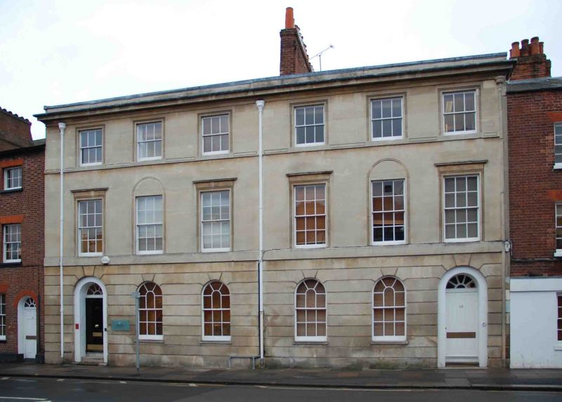
Pair of early-C19 terraced houses, now offices (2023).
Pair of early-C19 terraced houses, now offices.
MATERIALS: principal elevations of Bath Stone, red brick to the rear. The roof covering is slate, windows and doors are timber.
PLAN: each of the two houses is approximately square in plan, three bays wide and of three storeys plus basement under a pitched roof with parapet. The houses are served by a party wall stack.
EXTERIOR: the principle façade is of dressed Bath Stone with a rusticated ground floor, string courses at first and second floors and a projecting parapet cornice. The elevations of the two houses are mirrored. The entrances are in the outer bays, comprising four-panelled doors with fanlights within round-arched openings. The ground floor windows are round-headed sashes with glazing bars. First floor windows are six-over-six sashes, the outer ones with carved architraves and cornices, the central one within an incised round arch. Second floor windows are three-over-three sashes, with incised surrounds.
The rear elevation is of red brick. Despite some alterations the houses are essentially mirrored: doors in the outer bays with stair windows above, and a single window lighting each floor.
47 and 49 Castle Street are a pair of townhouses, probably of the early C19. The buildings are faced in Bath Stone, a comparatively expensive material which began to be transported into Reading via the Kennett and Avon Canal in the early 1800s.
Number 49 was advertised for rent in 1830, as ‘A Spacious FAMILY RESIDENCE… containing two parlours, drawing and anti-rooms, six bed-chambers, convenient offices, small garden, coach house and stable’. In the early 1830s, both properties were advertised for a limited number of young girls (at number 47) and boys (at number 49) to be taken in for tuition and boarding. By 1847 number 49 was recorded as a postal receiving house, whereas number 47 continued in educational use as late as 1860.
Further references to the two addresses in local newspapers indicate that for much of the C20 they were in residential use, but in the later part of the century they were converted to office use.
The long rear gardens, which extended south as far as Holy Brook, were truncated in the mid-C20 when the lower parts were sold to the Simonds Brewery to the southeast. The upper parts were amalgamated with neighbouring plots into a car park serving several properties on Castle Street during the 1980s or 1990s.
The crossroads formed by the north-south route of St Mary’s Butts/Bridge Street and the east-west route of Gun Street/Castle Street is believed to be the centre of the original Saxon settlement at Reading, established sometime before the ninth century. St Mary’s Church, which lies on the north-east corner of the crossroads, was the town’s primary church until the establishment of Reading Abbey in the C12 and became so again following the dissolution in the late 1530s.
Castle Street forms part of the ancient route through the town between London and the West Country, and historically contained many inns and guesthouses. As Reading expanded beyond its medieval limits during the C18 and C19, earlier buildings were gradually replaced with substantial townhouses and public buildings. Redevelopment was piecemeal and mostly confined to individual plots, leading to the street’s great architectural diversity.
This pattern was broken in the late 1960s and 1970s, with the construction of the expansive civic complex on the north side of Castle Street, and of the Inner Relief Road immediately to the west of the new complex. These major works required the demolition of most of the buildings on the north side of Castle Street, and separated the more commercial, eastern end of the street nearer the town centre from the more residential, western end of the street as it becomes Castle Hill.
47 and 49 Castle Street are listed at Grade II for the following principal reasons:
Architectural interest:
* as a pair of early-C19 houses, the fabric of which contributes to Reading’s rich and varied architectural character.
Historic interest:
* as part of the later urban development of Reading’s ancient core.
Group value:
* the pair are in close proximity to a number of listed buildings and contribute to a strong historic streetscape.
External links are from the relevant listing authority and, where applicable, Wikidata. Wikidata IDs may be related buildings as well as this specific building. If you want to add or update a link, you will need to do so by editing the Wikidata entry.


Other nearby listed buildings