Latitude: 51.4528 / 51°27'9"N
Longitude: -0.9757 / 0°58'32"W
OS Eastings: 471270
OS Northings: 173138
OS Grid: SU712731
Mapcode National: GBR QKG.YN
Mapcode Global: VHDWT.1RJ6
Plus Code: 9C3XF23F+4P
Entry Name: 43 Castle Street
Listing Date: 22 March 1957
Last Amended: 26 January 2024
Grade: II
Source: Historic England
Source ID: 1113417
English Heritage Legacy ID: 38800
ID on this website: 101113417
Location: Reading, Berkshire, RG1
County: Reading
Electoral Ward/Division: Abbey
Parish: Non Civil Parish
Built-Up Area: Reading
Traditional County: Berkshire
Lieutenancy Area (Ceremonial County): Berkshire
Church of England Parish: Reading St Giles
Church of England Diocese: Oxford
Tagged with: Building
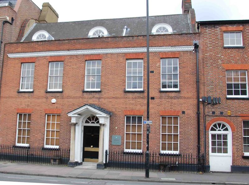
Townhouse, constructed during the late C18, extended by the mid-C19, converted to offices by 1953.
Townhouse, constructed during the late C18, extended by the mid-C19, converted to offices by 1953.
MATERIALS: the front elevation of the building is of red brick in Flemish bond, with a timber and stone doorcase and iron railings. The rear (south) elevation of the building is of vitrified, silver grey-brick in header bond with red-brick detailing and a timber doorcase. The roof covering is slate with lead-covered, timber dormers.
PLAN: double-pile plan.
EXTERIOR: the building is two storeys across five bays on its principal, north elevation, and three storeys across five bays on its rear (southern) elevation overlooking Rose Walk. The M-shaped roof contains three round-arched dormers facing onto Castle Street, while the gable end walls of the northern half of the building, now mostly concealed by later buildings, have Flemish gables. Large, brick chimney stacks rise from each of the gable end walls between the front and rear pitched roofs.
The principal Castle Street elevation is symmetrically arranged, with a central doorway flanked by two pairs of timber sash windows with six-over-six glazing, flat-arched heads and black painted cills, and five sash windows on the first floor of a matching design to the ground floor. The doorway consists of a six-panelled door with a sunburst cast-iron fanlight over, set within a Doric porch with stone columns rising from stone bases to a timber, moulded open pediment. Early-C19 iron spearhead railings surround a narrow front area to either side of the doorway. Immediately above the first-floor window heads is a dentil cornice of timber or plaster, followed by a red-brick, stone-coped parapet.
The rear elevation is symmetrically arranged over three storeys plus basement. It is faced in silver-grey brickwork in header bond with red-brick window surrounds and surrounds linked by columns of red brick. The raised ground floor contains a central entrance comprising a modern, half-glazed door with a sunburst fanlight above, contained within a timber porch with Doric pilasters rising to a moulded, open pediment. The doorway is accessed via a late-C20 brick flight of steps. To either side of the doorway are pairs of recent timber sashes. On the first and second floors are five, evenly-spaced, timber sash windows with six-over-six glazing and painted cills. Between the first and second floors is a dentil cornice in rubbed red brick. At basement level are four windows under flat-arched heads.
INTERIOR: the interior of the front range is understood to contain a staircase of around 1800.
The crossroads formed by the north-south route of St Mary’s Butts and Bridge Street and the east-west route of Gun Street and Castle Street is believed to be the centre of the original Saxon settlement at Reading, established sometime before the ninth century with the lowest crossing point of the River Kennet lying a short distance away to the south. Reading was well-established by the time of the Norman Conquest, and the Domesday Book (1086) records six mills and a large estate in the town. St Mary’s Church, which lies on the north-east corner of the crossroads and was mostly rebuilt in 1551-1555, was the town’s primary church until the establishment of Reading Abbey in the C12 and became so again following the dissolution in the late 1530s.
Running west from the crossroads, Castle Street forms part of the ancient route through the town between London and the West Country, and the street historically contained many inns and guesthouses. As Reading expanded beyond its medieval limits during the C18 and C19, development spread further along Castle Street. Until the mid-C20, redevelopment on the street was piecemeal and mostly confined to individual plots, leading to the street’s great architectural diversity. This pattern was broken in the late 1960s and 1970s, with the construction of the expansive civic complex on the north side of Castle Street, and of the Inner Relief Road immediately to the west of the new complex. These major works required the demolition of most of the buildings on the north side of Castle Street and severed the more commercial, eastern end of the street nearer the town centre and the more residential, western end of the street as it becomes Castle Hill.
43 Castle Street is a townhouse constructed during the late C18. Sales particulars of 1829 describe the house as containing seven bedrooms, offices, a walled garden, a coach house and stabling (Reading Mercury, 5 October 1829, p2). Originally built as a double-pile house under an M-shaped roof, a substantial extension was added to the rear of the building sometime before the early 1850s (Board of Health maps, John Clancy, 1853). The rear half of the building was extended upwards and to the south, creating a south-facing, three-storey frontage faced in vitrified, silver-grey brick with red-brick dressings.
The Ordnance Survey Town Plan of Reading (1:500, 1875) shows that the house had a large, formally laid-out garden which extended as far south as the Holy Brook (a tributary of the River Kennet). During the late C19 or early C20, number 43 was the home of Dr JB Hurry (1857-1930), a local doctor and amateur historian who wrote several books on the history of Reading Abbey.
During the late 1980s, the former rear garden of number 43 was developed with low-rise apartment blocks as part of the redevelopment of the Castle Brewery site. 43 Castle Street was converted from domestic to office use sometime before 1953 (Reading Standard, 2 April 1953, p10).
43 Castle Street, Reading, is listed at Grade II for the following principal reasons:
Architectural interest:
* as a late-C18 townhouse, with good detailing, which contributes to the character of an architecturally varied historic streetscape.
Historic interest:
* as part of the urban development of Reading’s ancient core.
Group value:
* the building is in close proximity to a large number of listed buildings and forms part of a strong historic grouping.
External links are from the relevant listing authority and, where applicable, Wikidata. Wikidata IDs may be related buildings as well as this specific building. If you want to add or update a link, you will need to do so by editing the Wikidata entry.


Other nearby listed buildings