History in Structure

45 Castle Street

A Grade II Listed Building in Abbey, Reading

More Photos »
Approximate Location Map
Large Map »

Coordinates

Latitude: 51.4527 / 51°27'9"N

Longitude: -0.9758 / 0°58'33"W

OS Eastings: 471260

OS Northings: 173133

OS Grid: SU712731

Mapcode National: GBR QKG.XP

Mapcode Global: VHDWT.1RG7

Plus Code: 9C3XF23F+3M

Entry Name: 45 Castle Street

Listing Date: 22 March 1957

Last Amended: 11 March 2024

Grade: II

Source: Historic England

Source ID: 1303711

English Heritage Legacy ID: 38801

ID on this website: 101303711

Location: Reading, Berkshire, RG1

County: Reading

Electoral Ward/Division: Abbey

Parish: Non Civil Parish

Built-Up Area: Reading

Traditional County: Berkshire

Lieutenancy Area (Ceremonial County): Berkshire

Church of England Parish: Reading St Giles

Church of England Diocese: Oxford

Tagged with: Building
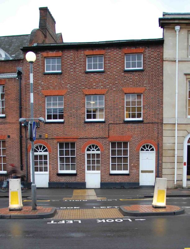
Summary


Early C19 townhouse, now offices (2023).

Description


Early C19 townhouse, now offices (2023).

MATERIALS: red and silver-grey bricks in Flemish bond. Brick and painted render to the rear.

PLAN: three storeys across three bays onto Castle Street under a pitched roof. Two and three-storey extensions to the rear, seemingly constructed in at least three phases. The former garden of the building has been developed, with neighbouring plots, as a car park.

EXTERIOR: the brickwork of the principal elevation has a decorative arrangement of burnt headers and red stretchers. The ground floor has been rebuilt and subsequently altered. There are three round-arched openings with fanlights, the westernmost opening has a six-panelled door and the two eastern openings have fixed, nine-pane windows. Between are two six-over-six sash windows with flat gauged-brick arches.

The first and second floors each have three windows under flat gauged-brick arches. The first-floor windows are six-over-six sashes, and the second-floor windows have horizontal proportions and were probably three-over-three sashes, now C20/C21 six-pane casements. There is a brick dentil course beneath the shallow projecting eaves.

To the rear, the early building has been obscured by later extensions of various dates. These are of brick and rendered brick with windows of different character and date. One of these extensions includes a piece of heavily weathered stonework carved with quatrefoils inset into the brickwork.

History


45 Castle Street appears to date from the early C19 and is likely to have been built as a townhouse. By 1835 it was in use as a boys’ preparatory school. In 1890 the upper floors were advertised for rent, possibly indicating the ground floor was in commercial use by this date.

Mapping of about 1875 shows the building with its current, extended, footprint, as well as a range of connected outbuildings along the western boundary of the plot, now lost.

During the C20, the building appears to have been combined with its neighbour to the east, 43 Castle Street (Grade II-listed) and was sometimes referred to as Abbotsbrook. Mentions of the property in local newspapers suggest various domestic and commercial configurations until at least 1968. The addresses seem to have been separated again by the mid-1970s and number 45 has remained in office use since that time.

The outbuildings to the rear of number 45 were demolished between 1980 and the late 1990s and a car park was created serving several properties on the south side of Castle Street.

The crossroads formed by the north-south route of St Mary’s Butts/Bridge Street and the east-west route of Gun Street/Castle Street is believed to be the centre of the original Saxon settlement at Reading, established sometime before the ninth century. St Mary’s Church, which lies on the north-east corner of the crossroads, was the town’s primary church until the establishment of Reading Abbey in the C12 and became so again following the dissolution in the late 1530s.

Castle Street forms part of the ancient route through the town between London and the West Country and historically contained many inns and guesthouses. As Reading expanded beyond its medieval limits during the C18 and C19 centuries earlier buildings were gradually replaced with substantial townhouses and public buildings. The redevelopment was piecemeal and mostly confined to individual plots, leading to the street’s great architectural diversity.

This pattern was broken in the late 1960s and 1970s, with the construction of the expansive civic complex on the north side of Castle Street, and of the Inner Relief Road immediately to the west of the new complex. These major works required the demolition of most of the buildings on the north side of Castle Street and separated the more commercial, eastern end of the street nearer the town centre from the more residential, western end of the street as it becomes Castle Hill.

Reasons for Listing


45 Castle Street is listed at Grade II for the following principal reasons:

Architectural interest:

* as an early-C19 building, the fabric of which contributes to Reading’s rich and varied architectural character.

Historic interest:

* as part of the later urban development of Reading’s ancient core.

Group value:

* the building is in close proximity to a number of listed buildings and contributes to a strong historic streetscape.

External Links

External links are from the relevant listing authority and, where applicable, Wikidata. Wikidata IDs may be related buildings as well as this specific building. If you want to add or update a link, you will need to do so by editing the Wikidata entry.

Recommended Books

Other nearby listed buildings

BritishListedBuildings.co.uk is an independent online resource and is not associated with any government department. All government data published here is used under licence. Please do not contact BritishListedBuildings.co.uk for any queries related to any individual listed building, planning permission related to listed buildings or the listing process itself.

British Listed Buildings is a Good Stuff website.