Latitude: 51.4571 / 51°27'25"N
Longitude: -0.9699 / 0°58'11"W
OS Eastings: 471668
OS Northings: 173631
OS Grid: SU716736
Mapcode National: GBR QMF.73
Mapcode Global: VHDWT.4MMT
Plus Code: 9C3XF24J+V3
Entry Name: Reading Museum
Listing Date: 24 July 1974
Grade: II
Source: Historic England
Source ID: 1321990
English Heritage Legacy ID: 38765
Also known as: Municipal Buildings Art Gallery And Museum
Reading Museum & Town Hall
Museum of Reading
Reading Museum and Art Gallery
ID on this website: 101321990
Location: Reading, Berkshire, RG1
County: Reading
Electoral Ward/Division: Abbey
Parish: Non Civil Parish
Built-Up Area: Reading
Traditional County: Berkshire
Lieutenancy Area (Ceremonial County): Berkshire
Church of England Parish: Reading St Mary the Virgin
Church of England Diocese: Oxford
Tagged with: Local museum Museum building Local authority museum
This list entry was subject to a Minor Amendment on 29/10/2019
SU 7173 NE
1/409
READING
Blagrave Street
Reading Museum
(Formerly listed as Municipal Buildings Art Gallery and Museum)
24.7.74.
GV
II
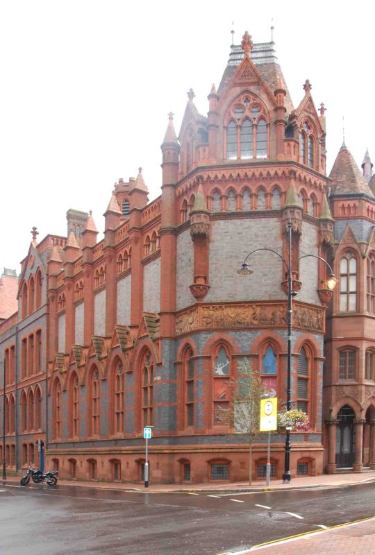
1894 designed by a local architect (W.R Howell) to fill corner between concert hall and earlier school of art (qv). Asymmetric design in Gothic style closely echoing the style of the concert hall. Two storeys attic and basement. Dark blue brick with dark red brick and terracotta dressings. Sandstone plinth. Terracotta band over ground floor, the carved reliefs depicting history of Reading; (incomplete but Saxon foundation, founding of Abbey and Magna Carta however can be seen). Arcaded cornice continued right across.
Projecting terracotta polygonal porch turret, heavy arcaded and decorated ground floor, gables over first floor windows. Three bay gable to right matches entrance to concert hall (coped gable, poppy head saddlestone, arcaded band and polygonal corner buttresses); two attic lancets flanking statue of Queen Victoria in canopied niche, C13 style. Two-light and oculus windows on first floor, segmental headed on ground floor. Corner block polygonal, basically a projecting chamfered turret with steep saddleback roof and three extremely rich gabled French Renaissance dormers with C13 geometrical tracery. First floor blind with three canopied niches on corners. On ground floor five foiled lancets and a basement of segmental headed windows. Commemorative marble tablet on corner. Return to Valpy Street repeats Waterhouse and Lainson use of triangular section buttresses capped with pinnacles between bays. Five bays. First floor blind, ground floor has two-light and oculus pointed windows with gables over. Tiled roofs. Octagonal belfry at east end, crenellated.
This composition is loosely said to be derived from Waterhouses Manchester Town Hall. Despite some similarities with other Gothic-style buildings in Manchester's Albert Square it is in fact much more closely related to the Waterhouse and Lainson blocks adjacent.
Listing NGR: SU7166873631
External links are from the relevant listing authority and, where applicable, Wikidata. Wikidata IDs may be related buildings as well as this specific building. If you want to add or update a link, you will need to do so by editing the Wikidata entry.


Other nearby listed buildings