Latitude: 51.1497 / 51°8'59"N
Longitude: 0.6888 / 0°41'19"E
OS Eastings: 588149
OS Northings: 142378
OS Grid: TQ881423
Mapcode National: GBR QV4.T49
Mapcode Global: VHJN2.WCHG
Plus Code: 9F324MXQ+VG
Entry Name: Perrin House
Listing Date: 10 October 1980
Grade: II
Source: Historic England
Source ID: 1323110
English Heritage Legacy ID: 181265
ID on this website: 101323110
Location: Smarden, Ashford, Kent, TN27
County: Kent
District: Ashford
Civil Parish: Smarden
Built-Up Area: Smarden
Traditional County: Kent
Lieutenancy Area (Ceremonial County): Kent
Tagged with: House
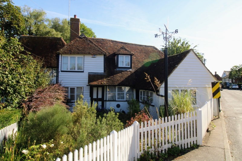
1.
5272 SMARDEN THE STREET
(north side)
Perrin House
TQ 8842 29/7
II GV
2.
Formerly the Forge. C17 or earlier timber-framed building, with the timbering
visible in the south-east wall but otherwise refaced with weatherboarding.
Half-hipped tiled roof. Casement windows. To the south is an L-wing, on the
ground floor level only.
Listing NGR: TQ8814942379
External links are from the relevant listing authority and, where applicable, Wikidata. Wikidata IDs may be related buildings as well as this specific building. If you want to add or update a link, you will need to do so by editing the Wikidata entry.


Other nearby listed buildings