Approximate Location Map
Large Map »
Latitude: 51.1496 / 51°8'58"N
Longitude: 0.6893 / 0°41'21"E
OS Eastings: 588183
OS Northings: 142362
OS Grid: TQ881423
Mapcode National: GBR QV4.T86
Mapcode Global: VHJN2.WCRL
Plus Code: 9F324MXQ+RP
Entry Name: Militia House
Listing Date: 12 March 1996
Grade: II
Source: Historic England
Source ID: 1255534
English Heritage Legacy ID: 459850
ID on this website: 101255534
Location: Smarden, Ashford, Kent, TN27
County: Kent
District: Ashford
Civil Parish: Smarden
Built-Up Area: Smarden
Traditional County: Kent
Lieutenancy Area (Ceremonial County): Kent
Tagged with: House
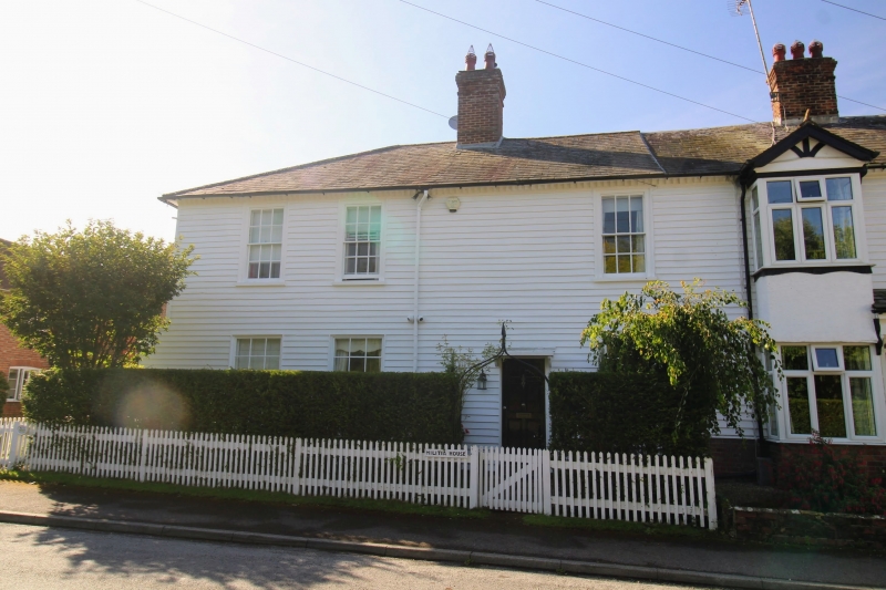
TQ 8842 SMARDEN THE STREET
29/10008 Militia House
II
House. Circa 1830-40. Part of a terrace of which the right hand property has been altered. Timber frame clad in weatherboarding. Slate roof, hipped to left with one central brick stack. Bracketed eaves cornice. Three irregularly spaced 12-pane sashes. First floor right window has three tall panes. Moulded architraves to most windows. Doorcase with flat hood and brackets and C20 panelled door. Interior has large C19 pilastered fireplace.
Listing NGR: TQ8818442360
External links are from the relevant listing authority and, where applicable, Wikidata. Wikidata IDs may be related buildings as well as this specific building. If you want to add or update a link, you will need to do so by editing the Wikidata entry.


Other nearby listed buildings
