Approximate Location Map
Large Map »
Latitude: 51.197 / 51°11'49"N
Longitude: 0.2755 / 0°16'31"E
OS Eastings: 559087
OS Northings: 146657
OS Grid: TQ590466
Mapcode National: GBR MP0.Y72
Mapcode Global: VHHQ6.Q5JQ
Plus Code: 9F3257WG+Q6
Entry Name: 127-131, High Street
Listing Date: 8 May 1950
Grade: II
Source: Historic England
Source ID: 1323170
English Heritage Legacy ID: 178682
ID on this website: 101323170
Location: Tonbridge, Tonbridge and Malling, Kent, TN9
County: Kent
District: Tonbridge and Malling
Electoral Ward/Division: Medway
Parish: Non Civil Parish
Built-Up Area: Tonbridge
Traditional County: Kent
Lieutenancy Area (Ceremonial County): Kent
Church of England Parish: Tonbridge St Peter and St Paul
Church of England Diocese: Rochester
Tagged with: Building
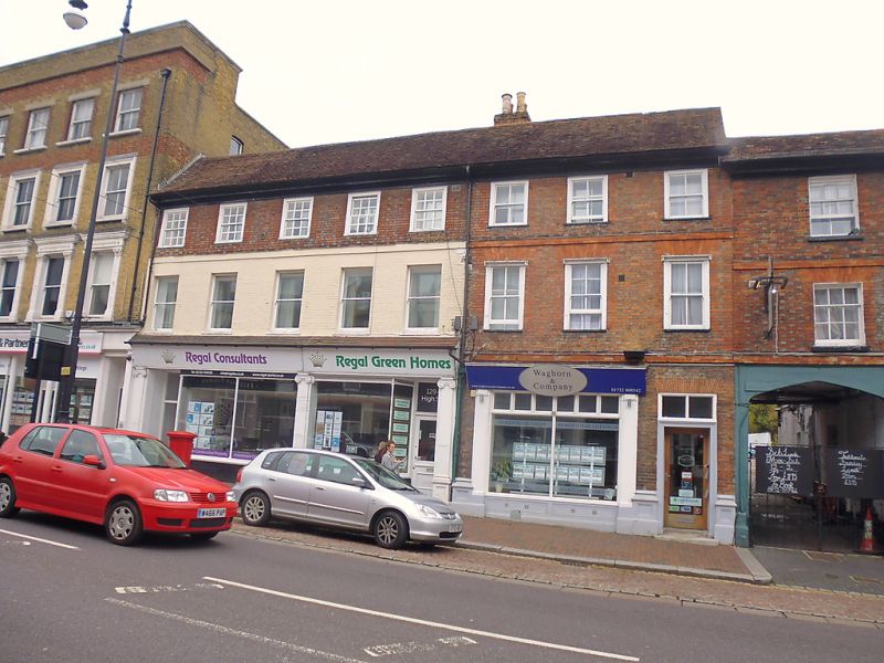
1. HIGH STREET
1732 (East Side)
Nos 127 to 131 (odd)
TQ 5946 NW 3/9 8.5.50.
II
GV
2.
C18 front. Possibly timber-framed buildings beneath like the Rose and Crown Hotel.
3 storeys. 8 windows in all. Red brick and grey headers. Brick stringcourses
above ground and first floors. Moulded wooden eaves cornice. Tiled roofs.
Glazing bars missing except in a few of the top floor windows of Nos 129 and
131. Modern shop fronts. The first floor of Nos 129 and 131 has been painted
white. The facade of these houses is similar to that of the Rose and Crown Hotel
with the exception that the elevation is slightly higher and the roof more
steeply pitched.
Nos 123, 125, The Rose and Crown Hotel, and Nos 127, 129, and 131 together
form a group
Listing NGR: TQ5908846654
External links are from the relevant listing authority and, where applicable, Wikidata. Wikidata IDs may be related buildings as well as this specific building. If you want to add or update a link, you will need to do so by editing the Wikidata entry.


Other nearby listed buildings
