Latitude: 54.7353 / 54°44'7"N
Longitude: -1.5753 / 1°34'31"W
OS Eastings: 427444
OS Northings: 537896
OS Grid: NZ274378
Mapcode National: GBR KFFP.R9
Mapcode Global: WHC4X.S71P
Plus Code: 9C6WPCPF+4V
Entry Name: Haybarn and Rear Yard Walls 110 Metres East of Croxdale Hall
Listing Date: 7 December 1987
Grade: II*
Source: Historic England
Source ID: 1323222
English Heritage Legacy ID: 109937
ID on this website: 101323222
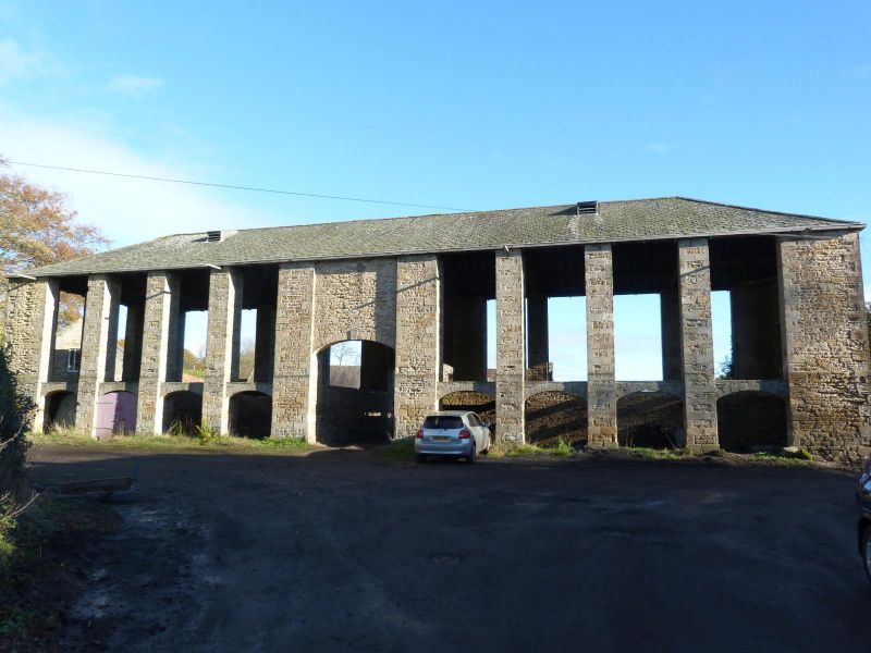
CROXDALE AND HETT CROXDALE HALL NZ 2737 17/56 Haybarn and rear yard walls, 110 metres east of Croxdale Hall II * Haybarn, incorporating cart sheds/hemmels on ground floor, with adjoining rear yard walls. Late C18-early C19. Coursed sandstone rubble and dressings. Graduated green slate roof. Tall barn above cart sheds/hemmels. 4 + 1 + 4 bays. Rectangular-plan piers at ends and flanking central bay, and similar square-plan piers between other bays, are set slightly forward of the archways and have flush, tooled-and-margined quoins. Tall elliptical archway at centre, with dropped keystone and blank wall above, leads through building into farmyard. Flanking sections each have 4 elliptical archways into cart sheds/ hemmels; 2 bays at left now garages with C20 double doors. Moderately-pitched hipped roof with strutted king-post trusses. 2-bay returns with central square- plan piers. Identical rear: 4-bay sections flanking centre back onto yards enclosed by 2.0-metre tall rubble walls with rounded coping stones. Yard on right rear is also subdivided into 3 parts by 2 similar parallel walls. A rare, impressive and unaltered example.
Listing NGR: NZ2744637897
External links are from the relevant listing authority and, where applicable, Wikidata. Wikidata IDs may be related buildings as well as this specific building. If you want to add or update a link, you will need to do so by editing the Wikidata entry.


Other nearby listed buildings