Approximate Location Map
Large Map »
Latitude: 54.9926 / 54°59'33"N
Longitude: -1.5962 / 1°35'46"W
OS Eastings: 425934
OS Northings: 566524
OS Grid: NZ259665
Mapcode National: GBR SRS.BM
Mapcode Global: WHC3K.GR4Y
Plus Code: 9C6WXCV3+3G
Entry Name: Chapel of St Mary
Listing Date: 14 June 1954
Grade: II*
Source: Historic England
Source ID: 1325172
English Heritage Legacy ID: 304809
Also known as: Chapel of St Mary, Jesmond
St Mary's Chapel
ID on this website: 101325172
Location: Jesmond, Newcastle upon Tyne, Tyne and Wear, NE2
County: Newcastle upon Tyne
Electoral Ward/Division: North Jesmond
Parish: Non Civil Parish
Built-Up Area: Newcastle upon Tyne
Traditional County: Northumberland
Lieutenancy Area (Ceremonial County): Tyne and Wear
Church of England Parish: Newcastle St George
Church of England Diocese: Newcastle
Tagged with: Chapel
NZ 26 NE NEWCASTLE UPON TYNE REID PARK ROAD
(east side)
9/322
14.6.54 Chapel of St. Mary
G.V. II*
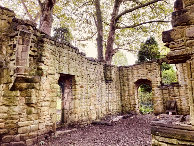
Chapel. First half C12; early C14 alterations and mid-C14 addition of sacristy.
Nave, chancel and north sacristy. Coursed squared sandstone. Roofless.
Fragments of east end of nave survive and shafts of chancel arch, which have
cushion capitals, (with scroll carving on that at south) and some voussoirs showing
roll and zig-zag mouldings. 2-light opening with cusped tracery in south chancel
wall, and 2 cusped ogee-headed lights in similar square-headed opening in north
sacristy wall. North door in sacristy. Interior shows piscinae: in chancel south
wall and sacristy. east wall. Walls survive up to a height of about 4 metres.
Source: W.F . Dendy in Archaeologia Aeliana 3rd series vol. I pp.130-147; M. Hope
Dodds History of Northumberland vol. XIII 1930 pp.298-310.
Listing NGR: NZ2593466524
External links are from the relevant listing authority and, where applicable, Wikidata. Wikidata IDs may be related buildings as well as this specific building. If you want to add or update a link, you will need to do so by editing the Wikidata entry.


Other nearby listed buildings
