Approximate Location Map
Large Map »
Latitude: 54.5338 / 54°32'1"N
Longitude: -2.3902 / 2°23'24"W
OS Eastings: 374846
OS Northings: 515459
OS Grid: NY748154
Mapcode National: GBR CJR0.BJ
Mapcode Global: WH937.891P
Plus Code: 9C6VGJM5+GW
Entry Name: Maypole to South of the Fox
Listing Date: 12 September 1957
Last Amended: 21 June 1984
Grade: II
Source: Historic England
Source ID: 1327004
English Heritage Legacy ID: 73399
ID on this website: 101327004
Location: Warcop, Westmorland and Furness, Cumbria, CA16
County: Cumbria
District: Eden
Town: Eden
Civil Parish: Warcop
Traditional County: Westmorland
Lieutenancy Area (Ceremonial County): Cumbria
Church of England Parish: Warcop St Columba
Church of England Diocese: Carlisle
Tagged with: Architectural structure High cross
NY 7415
WARCOP
B6259 WARCOP
(south side)
17/115
12.9.57
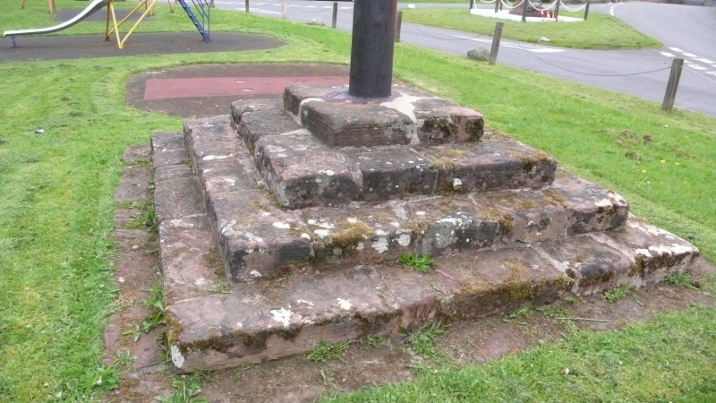
Maypole to south of
The Fox
(formerly listed as
Maypole on village green)
II
Maypole on cross base, possibly medieval. Base of steps constructed of
sandstone blocks. Tall wooden pole surmounted by decorative C20 weathervane.
Listing NGR: NY7484615459
External links are from the relevant listing authority and, where applicable, Wikidata. Wikidata IDs may be related buildings as well as this specific building. If you want to add or update a link, you will need to do so by editing the Wikidata entry.


Other nearby listed buildings
