Approximate Location Map
Large Map »
Latitude: 50.2291 / 50°13'44"N
Longitude: -5.1835 / 5°11'0"W
OS Eastings: 173045
OS Northings: 41421
OS Grid: SW730414
Mapcode National: GBR Z6.1PHW
Mapcode Global: FRA 081F.0G7
Plus Code: 9C2P6RH8+MJ
Entry Name: The Manse
Listing Date: 12 September 1989
Grade: II
Source: Historic England
Source ID: 1328133
English Heritage Legacy ID: 66663
ID on this website: 101328133
Location: Carharrack, Cornwall, TR16
County: Cornwall
Civil Parish: Carharrack
Built-Up Area: Carharrack
Traditional County: Cornwall
Lieutenancy Area (Ceremonial County): Cornwall
Church of England Parish: St Day
Church of England Diocese: Truro
Tagged with: Clergy house
CARHARRACK CHURCH STREET
SW 74 SW
(west side, off)
6/115
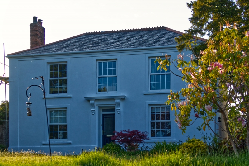
The Manse
GV II
Manse to Carharrack Wesleyan Chapel, now private dwelling c.1815. Uncoursed killas
rubble with granite quoins, mostly rendered, scantle slate roof, brick chimneys.
L-plan formed by single-depth front range with rear wing to left (modern
addition in rear angle not of special interest). Two storeys and 3 bays,
symmetrical, framed by a plinth, corner pilasters, and eaves band; the central
doorway (up 3 steps) has a pilastered architrave with cornice on fluted consoles,
and a recessed door (now plastic) with shallow overlight; the 2 windows at
ground floor and 3 above have raised sills and plain surrounds and are now
furnished with plastic top-hung casements imitating 16-pane sashes. Hipped roof
and side-wall chimneys. The left return wall has a 2-centred arched stairwindow
with altered glazing like that at the front. Interior: doglegged open-string
staircase with stick balusters and ramped handrail.
Included for group value with Carharrack Methodist Church to the right.
Listing NGR: SW7304541421
External links are from the relevant listing authority and, where applicable, Wikidata. Wikidata IDs may be related buildings as well as this specific building. If you want to add or update a link, you will need to do so by editing the Wikidata entry.


Other nearby listed buildings
