Latitude: 54.5494 / 54°32'58"N
Longitude: -1.1837 / 1°11'1"W
OS Eastings: 452897
OS Northings: 517439
OS Grid: NZ528174
Mapcode National: GBR NH5T.JX
Mapcode Global: WHD70.SXH6
Plus Code: 9C6WGRX8+QG
Entry Name: 33-55, HIGH STREET (See details for further address information)
Listing Date: 28 November 1972
Grade: II
Source: Historic England
Source ID: 1329509
English Heritage Legacy ID: 59737
ID on this website: 101329509
Location: Ormesby, Middlesbrough, North Yorkshire, TS7
County: Middlesbrough
Electoral Ward/Division: Park End & Beckfield
Parish: Non Civil Parish
Built-Up Area: Middlesbrough
Traditional County: Yorkshire
Lieutenancy Area (Ceremonial County): North Yorkshire
Church of England Parish: Ormesby St Cuthbert
Church of England Diocese: York
Tagged with: Building
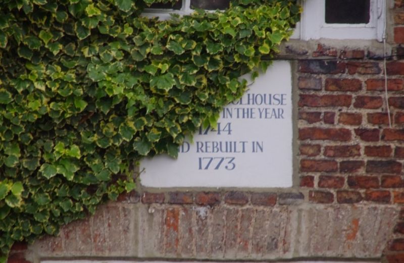
MIDDLESBROUGH HIGH STREET NZ 51 NW (5217) (north side), Ormesby. 4/41 Nos. 33 to 55 odd 28.ll.72 and No. 53A. G.V. II Terrace of 13 almshouses and school, mid/late C18 in 5 builds. School has mid C19 rear extension, almshouses have late C19 rear extensions. School at right end, now used as betting office and social club. Brick in English garden wall bond. Renewed clay pantile roofs; Welsh slate on school extension. Partly rebuilt brick stacks. 1 storey, 26 windows, with 2-storey, 1-window projecting end wings and slightly-projecting 2-storey, 2-window middle cottage (No. 45). Renewed boarded doors at Nos. 35 to 43, late C20 glazed doors at Nos. 45 to 53A. Nos. 33 and 55 entered from returns. Late C20 casement windows in original openings, except first floor of No. 33, tripartite window with renewed middle sash. Gauged brick flat arches over most openings. Painted tablet between floors at school: "THIS PUBLICK SCHOOL HOUSE WAS ERECTED IN THE YEAR 1744 AND REBUILT IN 1773". No. 45 has lozenge-shaped sundial dated 1776, between first-floor windows. Hipped roofs, sprocketed at eaves, on No. 45 and end wings. Ridge stacks at junctions and on wings. 1-window inner return of school has blocked doorway and horizontal sashes with glazing bars, altered on first floor. 1-window inner return of No. 55 has blocked door and late C20 door. Right return altered; 3-window left return of No. 55 has left late C20 door. 2-storey, 2-bay rear extension to No. 33. Mid/late C20 extensions at right and rear of school, are not of special interest.
Listing NGR: NZ5289717439
External links are from the relevant listing authority and, where applicable, Wikidata. Wikidata IDs may be related buildings as well as this specific building. If you want to add or update a link, you will need to do so by editing the Wikidata entry.


Other nearby listed buildings