Approximate Location Map
Large Map »
Latitude: 54.595 / 54°35'41"N
Longitude: -1.2936 / 1°17'37"W
OS Eastings: 445738
OS Northings: 522428
OS Grid: NZ457224
Mapcode National: GBR MHD9.QL
Mapcode Global: WHD6S.3R8S
Plus Code: 9C6WHPV4+XH
Entry Name: Glebe Farmhouse
Listing Date: 12 June 1973
Grade: II
Source: Historic England
Source ID: 1329809
English Heritage Legacy ID: 59202
ID on this website: 101329809
Location: Stockton-on-Tees, North Yorkshire, TS23
County: Stockton-on-Tees
Civil Parish: Billingham
Built-Up Area: Billingham
Traditional County: Durham
Lieutenancy Area (Ceremonial County): County Durham
Church of England Parish: Billingham
Church of England Diocese: Durham
Tagged with: Farmhouse
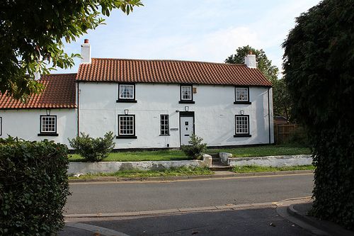
NZ 4522 BILLINGHAM CHAPEL ROAD
(South side)
24/418 Glebe Farmhouse
12.6.73
II
Early C18 appearance with alterations. Smooth rendered walls. High pitched
swept pantiled roof with end chimneys. Two storeys, three windows, with one-
storey, one-window left addition. Modern small paned casements and modern door
in original spaces.
Listing NGR: NZ4573822428
External links are from the relevant listing authority and, where applicable, Wikidata. Wikidata IDs may be related buildings as well as this specific building. If you want to add or update a link, you will need to do so by editing the Wikidata entry.


Other nearby listed buildings
