Approximate Location Map
Large Map »
Latitude: 53.1995 / 53°11'58"N
Longitude: -2.5398 / 2°32'23"W
OS Eastings: 364039
OS Northings: 367069
OS Grid: SJ640670
Mapcode National: GBR 7S.2FKV
Mapcode Global: WH99J.YVR2
Plus Code: 9C5V5FX6+Q3
Entry Name: Knights Grange Public House
Listing Date: 11 October 1949
Last Amended: 12 March 1986
Grade: II
Source: Historic England
Source ID: 1329819
English Heritage Legacy ID: 57382
ID on this website: 101329819
Location: Littler, Cheshire West and Chester, Cheshire, CW7
County: Cheshire West and Chester
Civil Parish: Winsford
Built-Up Area: Winsford
Traditional County: Cheshire
Lieutenancy Area (Ceremonial County): Cheshire
Church of England Parish: Whitegate St Mary
Church of England Diocese: Chester
Tagged with: Pub
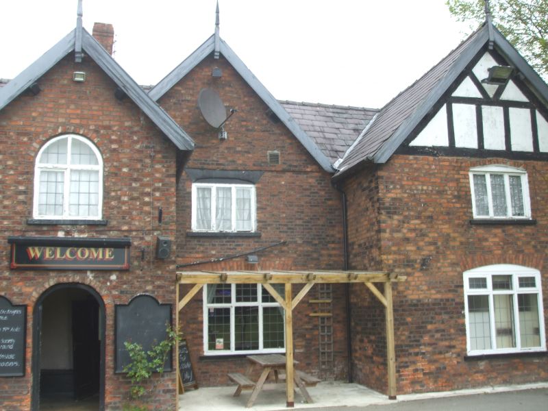
WINSFORD FORMER U.D. GRANGE LANE
SJ 66 NW
4/98 Knight's Grange Public
House. (Formerly listed
11.10.49 as Knight's Grange)
GV II
Farmhouse, now public house. Mid/late Cl7. Red English garden wall
bond with slate roof. Two storeys E-shaped plan. Entrance front:
Gabled 2-storey projecting porch to left of centre with round archway
and plank door within with nail head decoration. Two-light arched C20
window to first floor. To right is a 3-light cambered-headed window
to ground floor with a 3-light window above with a cambered relieving
arch. To right of this is a projecting wing with a 3-light
cambered-headed window with smaller similar window to first floor and
timbered gable above. To left of the porch are a set of 3 French
windows to ground floor with a 3-light first floor window above and
the wing to left has a cambered headed ground floor window with a
first floor window above of 3 lights. Right hand side has 2 massive
chimney breasts at right and left of centre.
Rear: Gabled wings to right and left with cambered headed 3-light
ground floor windows, that at right having a 3-light first floor
window and a timber framed gable with whitewashed brick infill, that
at left with a band of two bricks depth slightly above the level of
the imposed 2-light cambered headed window at first floor level. C20
outshut before the centre having double doors at right of centre with
a gable above. The house and adjacent barn (q.v.) were originally the
property of Vale Royal Abbey.
Listing NGR: SJ6403967069
External links are from the relevant listing authority and, where applicable, Wikidata. Wikidata IDs may be related buildings as well as this specific building. If you want to add or update a link, you will need to do so by editing the Wikidata entry.


Other nearby listed buildings
