Approximate Location Map
Large Map »
Latitude: 52.2206 / 52°13'14"N
Longitude: 0.1725 / 0°10'20"E
OS Eastings: 548498
OS Northings: 260268
OS Grid: TL484602
Mapcode National: GBR M8H.NG3
Mapcode Global: VHHK3.YG11
Plus Code: 9F4265CC+6X
Entry Name: Musgrave Farmhouse
Listing Date: 11 April 1980
Grade: II*
Source: Historic England
Source ID: 1331305
English Heritage Legacy ID: 50570
ID on this website: 101331305
Location: Fen Ditton, South Cambridgeshire, CB5
County: Cambridgeshire
District: South Cambridgeshire
Civil Parish: Fen Ditton
Built-Up Area: Fen Ditton
Traditional County: Cambridgeshire
Lieutenancy Area (Ceremonial County): Cambridgeshire
Church of England Parish: Fen Ditton St Mary the Virgin
Church of England Diocese: Ely
Tagged with: Farmhouse
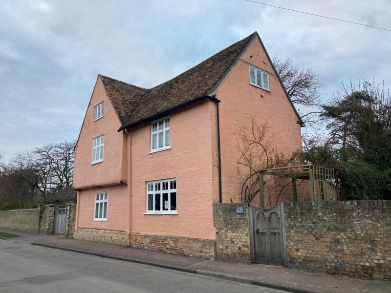
TL 4860-4960 FEN DITTON HIGH STREET
(North Side)
18/19 No. 10 (Musgrave
11.4.80 Farmhouse)
GV II*
Farmhouse. Late C16 and early C17 with C19 alterations and
additions. Timber-framed and plastered, C17 local brick, C19
gault brick casing. Plain tile roofs. Two storeys with
attics; L-Plan, C16 timber-framed cross-wing jettied to street
with later brick east range at right angles and C19 outshut in
angle. Ridge stack and large rear stack to east range. Street
elevation; brick plinth, one three-light attic casement window,
two first floor three-light transomed casement windows at ground
floor. Main entrance in west facing facade cased in gault
brick: four-panelled door with rectangular fanlight, cambered
brick arches to three first floor sixteen-paned recessed hung
sash windows, one similar ground floor window, and one larger
twelve-paned hung sash window. Interior details of C17
panelling see R.C.H.M. East Cambs. Recently discovered ovolo
moulded side lights to cross-wing windows. Painted imitation
panelling on east wall of first floor room in east wing. C16
cross-wing a surviving part of a building to the west.
R.C.H.M.: East Cambs p. 61, mon. 16.
Inclosure Award Map, 1807 C.R.O.
Listing NGR: TL4849860268
External links are from the relevant listing authority and, where applicable, Wikidata. Wikidata IDs may be related buildings as well as this specific building. If you want to add or update a link, you will need to do so by editing the Wikidata entry.


Other nearby listed buildings
