Latitude: 52.0497 / 52°2'58"N
Longitude: -0.7867 / 0°47'12"W
OS Eastings: 483299
OS Northings: 239729
OS Grid: SP832397
Mapcode National: GBR D01.KWT
Mapcode Global: VHDT0.9RZ2
Plus Code: 9C4X26X7+V8
Entry Name: Garden Wall to Street at Bradwell House
Listing Date: 28 August 1975
Grade: II
Source: Historic England
Source ID: 1332308
English Heritage Legacy ID: 45792
ID on this website: 101332308
Location: Heelands, Milton Keynes, Buckinghamshire, MK13
County: Milton Keynes
Civil Parish: Bradwell
Built-Up Area: Milton Keynes
Traditional County: Buckinghamshire
Lieutenancy Area (Ceremonial County): Buckinghamshire
Church of England Parish: Stantonbury and Willen
Church of England Diocese: Oxford
Tagged with: Wall
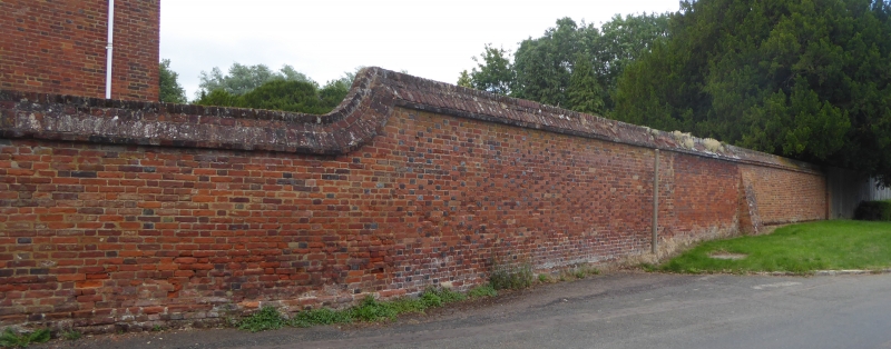
SP 83 NW BRADWELL LOUGHTON ROAD
east side
3/5 Garden Wall to Street at
Bradwell House (No.44)
28.8.75
GV II
Garden wall, C18 red brick about 2m high, with diaper pattern of blue
headers. Pitched and inset brick capping. Ramped down S. of porch
to Bradwell House.
Listing NGR: SP8331339724
External links are from the relevant listing authority and, where applicable, Wikidata. Wikidata IDs may be related buildings as well as this specific building. If you want to add or update a link, you will need to do so by editing the Wikidata entry.


Other nearby listed buildings