Latitude: 50.7918 / 50°47'30"N
Longitude: -1.0954 / 1°5'43"W
OS Eastings: 463855
OS Northings: 99522
OS Grid: SZ638995
Mapcode National: GBR VQB.KK
Mapcode Global: FRA 87L0.32G
Plus Code: 9C2WQWR3+PR
Entry Name: 24, Landport Terrace
Listing Date: 25 September 1972
Grade: II
Source: Historic England
Source ID: 1333167
English Heritage Legacy ID: 474846
ID on this website: 101333167
Location: Old Portsmouth, Portsmouth, Hampshire, PO1
County: City of Portsmouth
Electoral Ward/Division: St Thomas
Parish: Non Civil Parish
Built-Up Area: Portsmouth
Traditional County: Hampshire
Lieutenancy Area (Ceremonial County): Hampshire
Church of England Parish: Southsea St Luke and St Peter
Church of England Diocese: Portsmouth
Tagged with: Building
PORTSMOUTH
SZ6399 LANDPORT TERRACE, Southsea 774-1/12/387 (North East side) 25/09/72 No.24
GV II
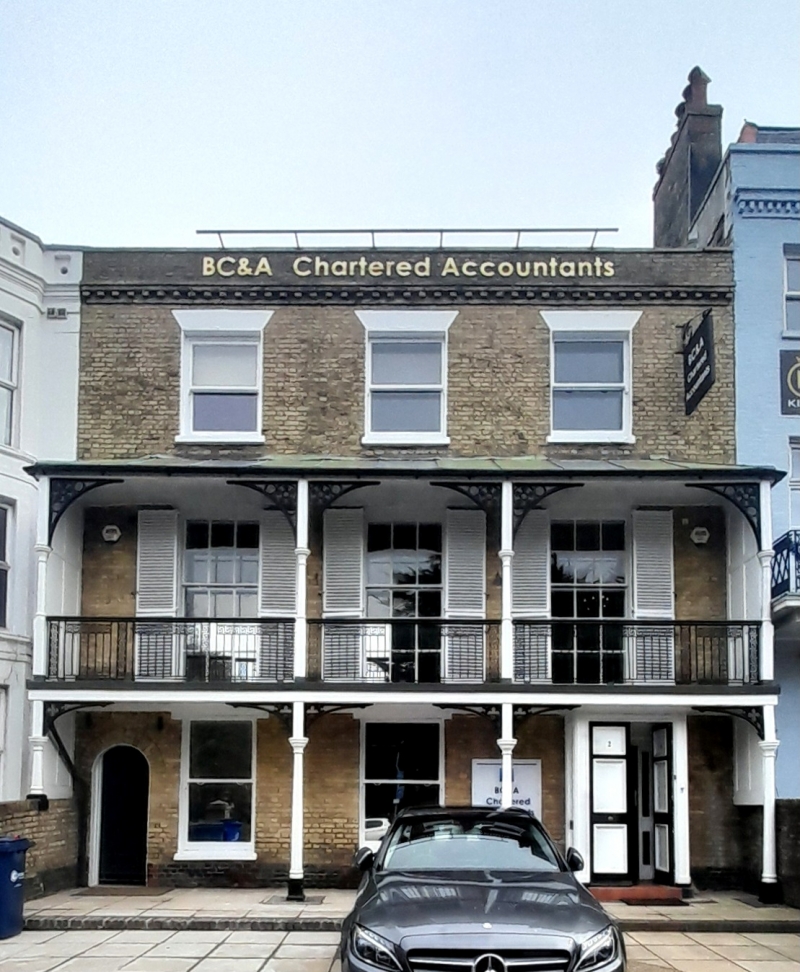
House, now offices. c1840, front restored late C20. Yellow stock bricks in Flemish bond. Plain tile hipped roof. 3 storeys, 3 bays. On right 2-leaf 6 moulded panel door set in C20 projecting porch under balcony with reeded architrave and cornice. To left 2 sashes then further left iron gate under segmental gauged brick arch. First floor has iron balcony with metal tent roof supported on ground and first floors each with 4 turned wood columns with geometrical patterned curved iron brackets, flanked with diagonal boarded sides. 3 high 15-pane unequal sashes lead to balcony. On second floor 3 sashes each set under flat rendered arches. Brick dentil course with stone cap, stone coped parapet. INTERIOR not inspected. (The Buildings of England: Pevsner N & Lloyd DW: Hampshire and the Isle of Wight: Harmondsworth: 1967-: 461).
Listing NGR: SZ6385599522
External links are from the relevant listing authority and, where applicable, Wikidata. Wikidata IDs may be related buildings as well as this specific building. If you want to add or update a link, you will need to do so by editing the Wikidata entry.


Other nearby listed buildings