Approximate Location Map
Large Map »
Latitude: 52.2435 / 52°14'36"N
Longitude: 0.7131 / 0°42'47"E
OS Eastings: 585327
OS Northings: 264060
OS Grid: TL853640
Mapcode National: GBR QF0.73Z
Mapcode Global: VHKD4.9WV0
Plus Code: 9F426PV7+C6
Entry Name: The Masons Arms Public House
Listing Date: 12 July 1972
Grade: II
Source: Historic England
Source ID: 1334446
English Heritage Legacy ID: 467758
Also known as: The Mason Arms, Bury St. Edmunds
The Mason Arms
ID on this website: 101334446
Location: Bury St Edmunds, West Suffolk, IP33
County: Suffolk
District: West Suffolk
Civil Parish: Bury St Edmunds
Built-Up Area: Bury St Edmunds
Traditional County: Suffolk
Lieutenancy Area (Ceremonial County): Suffolk
Church of England Parish: Bury St Edmunds St Mary
Church of England Diocese: St.Edmundsbury and Ipswich
Tagged with: Pub
BURY ST EDMUNDS
TL8564SW WHITING STREET
639-1/14/697 (East side)
12/07/72 No.14
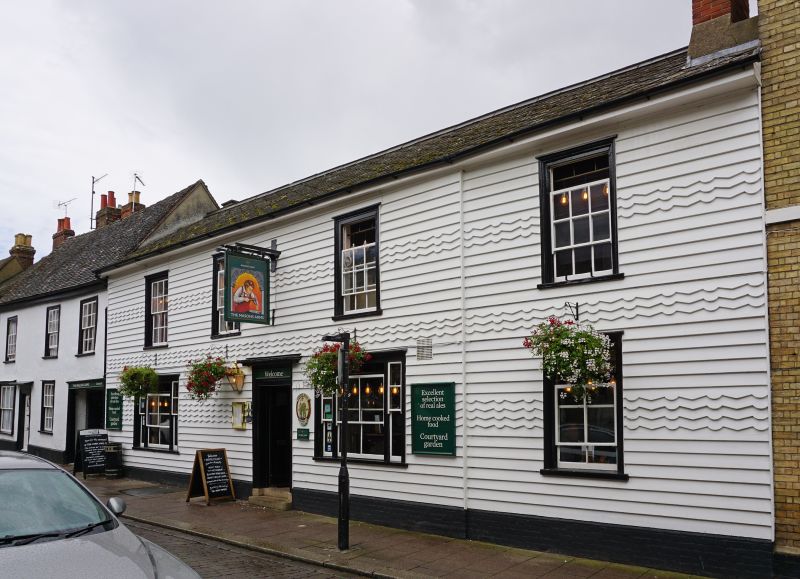
The Masons Arms Public House
GV II
Public house. Early C16. Timber-framed; faced in alternating
sections of plain and fluted C19 weatherboarding. Shallow
pitched roof of asbestos slates.
EXTERIOR: 2 storeys and cellars; formerly with a hall range
and 2 cross-wings. 4 window to the 1st storey: 12-pane sash
windows in flush cased frames. 3 windows on the ground storey:
2 tripartite sashes and one plain sash, each with a single
vertical glazing bar to the main lights. A moulded architrave
and cornice to the doorway. A rendered cross-wing at the rear.
INTERIOR: brick-lined cellar. On the ground storey all the
ceiling timbers are exposed in the centre 2 bays of the former
hall: chamfered main cross-beams with curved stepped stops,
unchamfered joists set flat. The cross-wing at the south end
has very heavy studding along its north wall with the infill
removed, and the centre section is butted up against it with
simply a main beam and middle rail to its frame. The rear of
this wing now forms part of the back premises of No.15 (qv),
which adjoins on the south. The wing on the north has only the
main beams exposed. There is said to be no timbering exposed
on the upper storey.
Listing NGR: TL8532764060
External links are from the relevant listing authority and, where applicable, Wikidata. Wikidata IDs may be related buildings as well as this specific building. If you want to add or update a link, you will need to do so by editing the Wikidata entry.


Other nearby listed buildings
