Approximate Location Map
Large Map »
Latitude: 53.1742 / 53°10'26"N
Longitude: -1.6385 / 1°38'18"W
OS Eastings: 424263
OS Northings: 364176
OS Grid: SK242641
Mapcode National: GBR 58F.0KL
Mapcode Global: WHCDF.SGZZ
Plus Code: 9C5W59F6+MJ
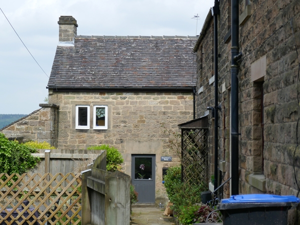
Entry Name: Swallow's Hole
Listing Date: 14 February 1985
Last Amended: 5 September 1995
Grade: II
Source: Historic England
Source ID: 1334985
English Heritage Legacy ID: 81051
ID on this website: 101334985
Location: Stanton, Derbyshire Dales, Derbyshire, DE4
County: Derbyshire
District: Derbyshire Dales
Civil Parish: Stanton
Traditional County: Derbyshire
Lieutenancy Area (Ceremonial County): Derbyshire
Church of England Parish: Stanton-in-Peak Holy Trinity
Church of England Diocese: Derby
Tagged with: Architectural structure
In the entry for:
SK 26 SW STANTON IN THE PEAK MAIN STREET
(north side)
4/52 Cottage and outbuilding
north of Lathkill View
II
The entry shall be amended to read:
SK 26 SW STANTON IN THE PEAK MAIN STREET
(north side)
354-/4/52 Swallow's Hole
14/02/85 (formerly listed as Cottage
and outbuilding north of
Lathkill View)
II
Cottage and attached outbuilding, now all one dwelling. Late C18, with C19 addition and C20
alteration. Coursed squared gritstone with gritstone dressings and quoins. Plain tile roof
covering, with stone gable end stack to west. Two storeys, 2 bays that to the east recessed. Flush
doorcase with C20 half-glazed door, and to the west, stacked 2-light flush-mullioned windows.
C19 former outbuilding to east, now part of dwelling, with C20 openings.
------------------------------------
SK 26 SW PARISH OF STANTON IN THE PEAK MAIN STREET
4/52 (North side)
Cottage and outbuilding
north of Lathkill View
II
Cottage and outbuilding. Late C18 with C19 addition. Coursed squared gritstone with
gritstone dressings and quoins. Stone slate roof with stone gable end stack to
west. Plain tile roof to addition. Two storeys, 2 bays, that to the east recessed.
Flush doorcase with plank door and to west, 2-light flush mullion window. C19
addition to east blank. Above, to west, similar window to that below.
Listing NGR: SK2426364176
This text is from the original listing, and may not necessarily reflect the current setting of the building.
External links are from the relevant listing authority and, where applicable, Wikidata. Wikidata IDs may be related buildings as well as this specific building. If you want to add or update a link, you will need to do so by editing the Wikidata entry.


Other nearby listed buildings
