Approximate Location Map
Large Map »
Latitude: 51.4045 / 51°24'16"N
Longitude: 0.2376 / 0°14'15"E
OS Eastings: 555732
OS Northings: 169647
OS Grid: TQ557696
Mapcode National: GBR VL.BJY
Mapcode Global: VHHP1.2YGQ
Plus Code: 9F32C63Q+Q2
Entry Name: Hill Charity Almshouses
Listing Date: 24 June 1977
Grade: II
Source: Historic England
Source ID: 1336460
English Heritage Legacy ID: 172716
ID on this website: 101336460
Location: South Darenth, Dartford, Kent, DA4
County: Kent
District: Dartford
Civil Parish: Sutton-at-Hone and Hawley
Built-Up Area: South Darenth
Traditional County: Kent
Lieutenancy Area (Ceremonial County): Kent
Church of England Parish: Sutton At Hone St John the Baptist
Church of England Diocese: Rochester
Tagged with: Almshouse
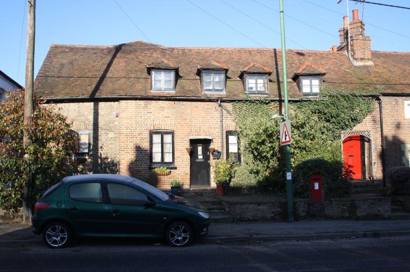
1.
5274 SUTTON-AT-HONE MAIN ROAD
(west side)
Nos 266 to 272 (even)
(Hill Charity Almshouses)
TQ 56 NE 7/85 24.6.77
II GV
2.
Nos 266 and 268 front the main road. Nos 270 and 272 are attached to the rear.
Nos 266 and 272 are C18. One storey and attics red brick with some grey headers.
The left bay of No 268 is early C19 in stock brick. Old tiled roof with 3 hipped
dormers. Four windows, mainly casements but one sash with glazing bars intact
to No 268. Simple doorcases, No 268 retaining its flat wooden hood on brackets.
Flight of stone steps to street. Nos 270 and 272 are mid C19 buildings to the
rear of stucco storeys. Stock brick. Brick modillion cornice. Four sashes.
Simple doorcases.
Listing NGR: TQ5573269647
External links are from the relevant listing authority and, where applicable, Wikidata. Wikidata IDs may be related buildings as well as this specific building. If you want to add or update a link, you will need to do so by editing the Wikidata entry.


Other nearby listed buildings
