Latitude: 51.4099 / 51°24'35"N
Longitude: 0.2361 / 0°14'10"E
OS Eastings: 555613
OS Northings: 170251
OS Grid: TQ556702
Mapcode National: GBR VK.XWZ
Mapcode Global: VHHP1.1TPJ
Plus Code: 9F32C65P+XF
Entry Name: The Hollies
Listing Date: 17 March 1982
Grade: II
Source: Historic England
Source ID: 1348521
English Heritage Legacy ID: 172714
ID on this website: 101348521
Location: Sutton at Hone, Dartford, Kent, DA4
County: Kent
District: Dartford
Civil Parish: Sutton-at-Hone and Hawley
Built-Up Area: South Darenth
Traditional County: Kent
Lieutenancy Area (Ceremonial County): Kent
Church of England Parish: Sutton At Hone St John the Baptist
Church of England Diocese: Rochester
Tagged with: Architectural structure
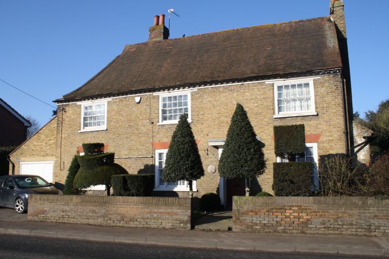
1.
5274 SUTTON-AT-HONE MAIN ROAD
(west side)
No 66
(The Hollies)
TQ 57 SE 4/79
II
2.
C17 or earlier timber-framed building refaced in C18. Two storeys faced with
buff bricks. Tiled roof with modillion eaves cornice. Three sashes with glazing
bars. Doorcase with pilasters and projecting cornice over, panelled reveals and
6 panelled door, the top 4 panels cut away and glazed. One ground floor window
of 3-lights.
Listing NGR: TQ5561370251
External links are from the relevant listing authority and, where applicable, Wikidata. Wikidata IDs may be related buildings as well as this specific building. If you want to add or update a link, you will need to do so by editing the Wikidata entry.


Other nearby listed buildings