Approximate Location Map
Large Map »
Latitude: 51.6485 / 51°38'54"N
Longitude: 0.0646 / 0°3'52"E
OS Eastings: 542937
OS Northings: 196433
OS Grid: TQ429964
Mapcode National: GBR N6.NZN
Mapcode Global: VHHMS.2TJM
Plus Code: 9F32J3X7+CR
Entry Name: 7, Rowans Way
Listing Date: 29 May 1984
Grade: II
Source: Historic England
Source ID: 1337275
English Heritage Legacy ID: 118642
ID on this website: 101337275
Location: Loughton, Epping Forest, Essex, IG10
County: Essex
District: Epping Forest
Civil Parish: Loughton
Built-Up Area: Loughton
Traditional County: Essex
Lieutenancy Area (Ceremonial County): Essex
Church of England Parish: Loughton St Mary the Virgin
Church of England Diocese: Chelmsford
Tagged with: Building
TQ 49 NW
1/35
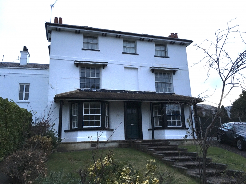
LOUGHTON,
ROWANS WAY,
No. 7,
GV II
House, early C16 and C17, extensively altered in early C19. Timber-framed and brick, part stuccoed, part weatherboarded, part painted brick, slate roof. The earliest part is a crosswing of 2 bays aligned approx. NW-SE, jettied to the SW, early C16, of a medieval hall which formerly extended to the NE. External chimney stack on NE side of SE bay, late C16. Extension to the SW of the SE bay, C17. Extensions to SW and W of this, forming a fashionable early C19 front to the SW, with chimney stacks at both sides. 3 storeys. Ground floor, central 6-panel door with top panels glazed, fluted pilasters, shallow hood, early C19. 2 bays of double-hung sash windows and tiled canopy across whole front, C19/20. First floor, 2 double-hung sash windows of 16 lights. C20, with shallow hoods and rectangular recess between. String course above. Second floor, 3 double-hung sash windows of 6 lights, early C19 and reproduction. Hipped roof of shallow pitch with projecting eaves and paired brackets, early C19. Crownpost roof, plain crownpost with axial braces only.
The earliest part of the building originally formed a 'Unit System' group with No. 53 Traps Hill the first identified in Essex, fully described and its ownership documented in K. L. Sandall: The Unit System in Essex, Archaeological Journal vol.130, 1975, 195-201.
Listing NGR: TQ4293796433
External links are from the relevant listing authority and, where applicable, Wikidata. Wikidata IDs may be related buildings as well as this specific building. If you want to add or update a link, you will need to do so by editing the Wikidata entry.


Other nearby listed buildings
