Approximate Location Map
Large Map »
Latitude: 51.6379 / 51°38'16"N
Longitude: -2.1592 / 2°9'33"W
OS Eastings: 389076
OS Northings: 193246
OS Grid: ST890932
Mapcode National: GBR 1P0.6XW
Mapcode Global: VH95K.J3C6
Plus Code: 9C3VJRQR+58
Entry Name: The Manse
Listing Date: 6 September 1954
Grade: II
Source: Historic England
Source ID: 1341204
English Heritage Legacy ID: 128402
ID on this website: 101341204
Location: Tetbury, Cotswold, Gloucestershire, GL8
County: Gloucestershire
District: Cotswold
Civil Parish: Tetbury
Built-Up Area: Tetbury
Traditional County: Gloucestershire
Lieutenancy Area (Ceremonial County): Gloucestershire
Church of England Parish: Tetbury St Mary the Virgin
Church of England Diocese: Gloucester
Tagged with: Clergy house
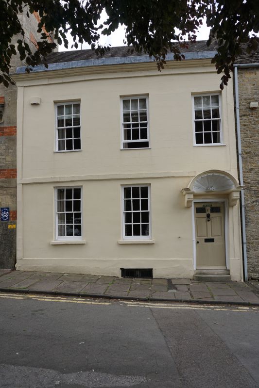
ST 8893-8993 TETBURY THE CHIPPING
(west side)
7/126 No 10 (The Manse)
6.9.54
GV II
House in terrace. Early/mid C18. Rendered front, tile roof, no
stacks visible. 2 storeys. 3 windows, 12-pane sashes in plain
reveals. 2 similar on ground floor with doorway to right, up 2
steps. 6-panel door, middle 2 fielded, and shell hood over
supported on brackets cutting into string course over ground floor
windows. Side vertical strips, cornice and blocking course, on
high plinth. Cellar window to left of doorway.
Listing NGR: ST8907693246
External links are from the relevant listing authority and, where applicable, Wikidata. Wikidata IDs may be related buildings as well as this specific building. If you want to add or update a link, you will need to do so by editing the Wikidata entry.


Other nearby listed buildings
