Latitude: 53.6307 / 53°37'50"N
Longitude: -1.7491 / 1°44'56"W
OS Eastings: 416689
OS Northings: 414941
OS Grid: SE166149
Mapcode National: GBR JV7G.36
Mapcode Global: WHCB2.3ZCZ
Plus Code: 9C5WJ7J2+79
Entry Name: 40-44, Westgate
Listing Date: 29 September 1978
Grade: II
Source: Historic England
Source ID: 1343328
English Heritage Legacy ID: 421015
ID on this website: 101343328
Location: Almondbury, Kirklees, West Yorkshire, HD5
County: Kirklees
Electoral Ward/Division: Almondbury
Parish: Non Civil Parish
Built-Up Area: Huddersfield
Traditional County: Yorkshire
Lieutenancy Area (Ceremonial County): West Yorkshire
Church of England Parish: Almondbury with Farnley Tyas Team Parish
Church of England Diocese: Leeds
Tagged with: Building
This List Entry was subject to a Minor Amendment on 02/09/2016
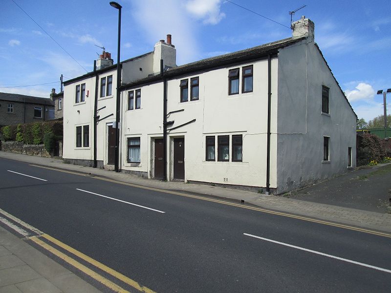
WESTGATE
1.
5113
(North Side)
Almondbury
Nos 40 to 44 (even)
SE 1614 45/1378
II
2.
C19. Render covered red brick front, with hammer dressed stone elsewhere, and ashlar window
dressings and mullions. Pitched stone slate roof. 2 storeys. No 40 has two
2-light stone mullioned sashes on 1st floor, and one 3-light stone mullioned
casement on ground floor. No 42 has one 2-light stone mullioned sash on 1st
floor, and one casement on ground floor. No 44 has two 2-light stone mullioned
sashes on 1st floor, and one on ground floor. One door each, with 4 moulded
porch. Lean-to outshut to rear.
Listing NGR: SE1668914941
External links are from the relevant listing authority and, where applicable, Wikidata. Wikidata IDs may be related buildings as well as this specific building. If you want to add or update a link, you will need to do so by editing the Wikidata entry.


Other nearby listed buildings