Approximate Location Map
Large Map »
Latitude: 51.148 / 51°8'52"N
Longitude: -2.7154 / 2°42'55"W
OS Eastings: 350052
OS Northings: 138989
OS Grid: ST500389
Mapcode National: GBR MK.7XJH
Mapcode Global: VH8B3.WD9T
Plus Code: 9C3V47XM+5R
Entry Name: St George's Hall
Listing Date: 21 June 1950
Grade: II
Source: Historic England
Source ID: 1345425
English Heritage Legacy ID: 265929
ID on this website: 101345425
Location: Glastonbury, Somerset, BA6
County: Somerset
District: Mendip
Civil Parish: Glastonbury
Built-Up Area: Glastonbury
Traditional County: Somerset
Lieutenancy Area (Ceremonial County): Somerset
Tagged with: Architectural structure
HIGH STREET
1.
1133
(North Side)
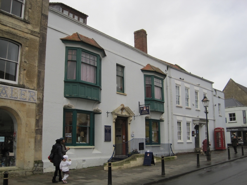
No 29
(St George's Hall)
ST 5039 6/39 21.6.50.
ST 5038 8/39
II GV
2.
A house dating from about 1700, front much altered. 2 storeys plus attic. Roughcast.
Pantile roof. Band defining frieze, coping. 3 windows. C19 oriels with tiled
roofs to 1st floor. C19 bays to ground floor in splayed recesses with flanking
squinches and dentilled cornices. Bays have 5-light sashes with a few glazing
bars to upper floor. Very good moulded wood doorcase of earlier period, with broken
pediment, inset acorn ornament, fluted pilasters and floriated volutes. Original
10-panel door. Interior has panelling etc of about 1700, and plasterwork to ceiling
of stairwell. The staircase itself is now in America.
The listed buildings from No 25 to No 31 (North side) form an important group with
No 2 Church Lane.
Listing NGR: ST5005238989
External links are from the relevant listing authority and, where applicable, Wikidata. Wikidata IDs may be related buildings as well as this specific building. If you want to add or update a link, you will need to do so by editing the Wikidata entry.


Other nearby listed buildings
