Latitude: 51.0521 / 51°3'7"N
Longitude: -2.7284 / 2°43'42"W
OS Eastings: 349037
OS Northings: 128337
OS Grid: ST490283
Mapcode National: GBR MK.G0KK
Mapcode Global: FRA 565B.NVJ
Plus Code: 9C3V372C+RJ
Entry Name: Crane Farmhouse
Listing Date: 17 April 1959
Grade: II*
Source: Historic England
Source ID: 1346065
English Heritage Legacy ID: 263026
ID on this website: 101346065
Location: Lower Somerton, Somerset, TA11
County: Somerset
District: South Somerset
Civil Parish: Somerton
Built-Up Area: Somerton
Traditional County: Somerset
Lieutenancy Area (Ceremonial County): Somerset
Tagged with: Farmhouse
ST42NE SOMERTON CP PESTERS LANE (south side)
4/218 Crane Farmhouse
17.4.59
GV II*
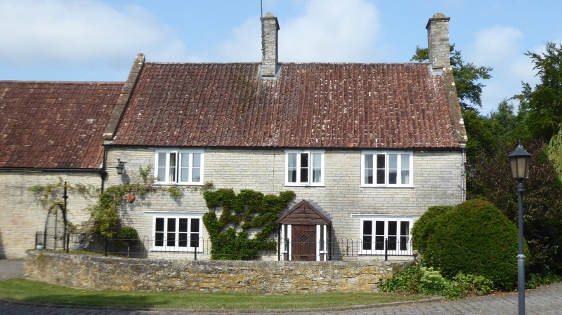
Farmhouse. Medieval origins, extended C17 and remodelled C19. Local lias stone cut and squared, Ham stone dressings; clay pantiled roof between coped gables with gabletted finials; stone chimney stacks. Complex closed U-plan; the north west section thought to be medieval, the south east of C17 with rebuilt front in C19. Two storeys, 3 bay east elevation. Horizontal bar casement windows, 4 light to outer bays and 3 light upper; central pointed arched doorway protected by timber, glass and tile porch. In ground floor of north gable a hollow chamfer mullioned 2-light window with hood mould, possibly reset; sundry straight joints in this gable, and at bottom right a relieving arch going below ground level. Interior not seen, but reported are two massive cruck trusses in north west section with tenoned purlins and one row of wind braces, some smoke blackening; in south west section a room with 12 panel framed ceiling, curved head fireplace, flagstone floor. An important house, with attached barn (qv) and nearby Pigeon House (qv), which represents the abandoned capital messuage of the former Somerton Erleigh estate. (VAG Report, unpublished SRO, 1981).
Listing NGR: ST4906928306
External links are from the relevant listing authority and, where applicable, Wikidata. Wikidata IDs may be related buildings as well as this specific building. If you want to add or update a link, you will need to do so by editing the Wikidata entry.


Other nearby listed buildings