Latitude: 53.5989 / 53°35'56"N
Longitude: -2.1429 / 2°8'34"W
OS Eastings: 390638
OS Northings: 411379
OS Grid: SD906113
Mapcode National: GBR FVGT.VM
Mapcode Global: WHB8Y.1SVW
Plus Code: 9C5VHVX4+HR
Entry Name: 33 and 35 Broad Lane and attached flagstone boundary wall to east
Listing Date: 12 February 1985
Grade: II
Source: Historic England
Source ID: 1346243
English Heritage Legacy ID: 358859
ID on this website: 101346243
Location: Buersil, Rochdale, Greater Manchester, OL16
County: Rochdale
Electoral Ward/Division: Kingsway
Parish: Non Civil Parish
Built-Up Area: Rochdale
Traditional County: Lancashire
Lieutenancy Area (Ceremonial County): Greater Manchester
Church of England Parish: Balderstone St Mary
Church of England Diocese: Manchester
Tagged with: Building
This list entry was subject to a Minor Amendment on 20 March 2025 to reformat the text to current standards
SD 91 SW
7/32
ROCHDALE
BROAD LANE (north side)
Nos. 33 and 35 and attached flagstone boundary wall to east
(Formerly listed as Nos. 33 and 35, BROAD LANE)
GV
II
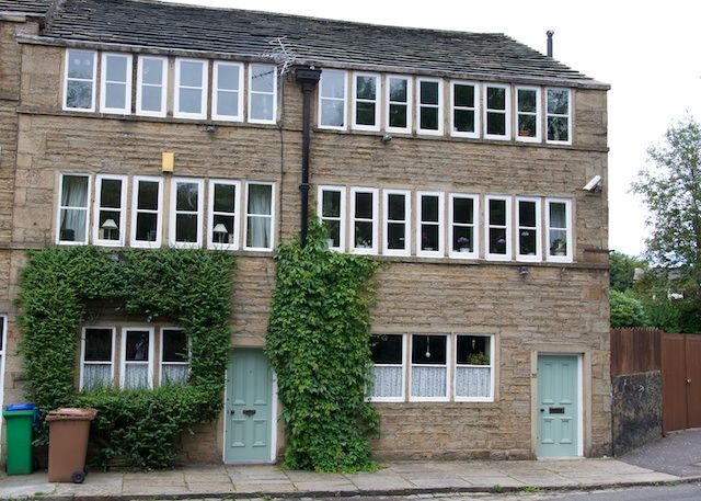
Weavers houses. Said to be dated 1787 on a ceiling beam of No. 33. Watershot stone to front and rear, random rubble to gable, stone slate roof. Each house is double-depth, of one bay and three storeys, the houses being linked by interconnecting door. Doors have monolithic stone jambs and lintels. Each house has a three-light flat-faced stone mullion window to the ground floor; No. 35 has eight-light "weaver's window" to the upper floors, No. 33 six-light. Stone quoins and sill banding. Rear has three- and four-light windows. All casements are C20.
Flagstone boundary wall to east, comprised of massive sandstone slabs approximately 1.75 metres high, of random widths, set well into the ground and joined at mid-height by small metal plates bolted together. The wall encloses a triangular-shaped garden and is approximately 80 metres in length
Listing NGR: SD9063811379
This list entry was subject to a Minor Amendment on 20 March 2025 to reformat the text to current standards
SD 91 SW
7/32
ROCHDALE
BROAD LANE (north side)
Nos. 33 and 35 and attached flagstone boundary wall to east
(Formerly listed as Nos. 33 and 35, BROAD LANE)
GV
II
Weavers houses. Said to be dated 1787 on a ceiling beam of No. 33. Watershot stone to front and rear, random rubble to gable, stone slate roof. Each house is double-depth, of one bay and three storeys, the houses being linked by interconnecting door. Doors have monolithic stone jambs and lintels. Each house has a three-light flat-faced stone mullion window to the ground floor; No. 35 has eight-light "weaver's window" to the upper floors, No. 33 six-light. Stone quoins and sill banding. Rear has three- and four-light windows. All casements are C20.
Flagstone boundary wall to east, comprised of massive sandstone slabs approximately 1.75 metres high, of random widths, set well into the ground and joined at mid-height by small metal plates bolted together. The wall encloses a triangular-shaped garden and is approximately 80 metres in length
Listing NGR: SD9063811379
External links are from the relevant listing authority and, where applicable, Wikidata. Wikidata IDs may be related buildings as well as this specific building. If you want to add or update a link, you will need to do so by editing the Wikidata entry.


Other nearby listed buildings