Latitude: 53.6768 / 53°40'36"N
Longitude: -0.7237 / 0°43'25"W
OS Eastings: 484406
OS Northings: 420792
OS Grid: SE844207
Mapcode National: GBR RTDX.3Q
Mapcode Global: WHFDM.VVK5
Plus Code: 9C5XM7GG+PG
Entry Name: Grange House (On Corner with Cow or Pinfold Lane)
Listing Date: 17 June 1987
Grade: II
Source: Historic England
Source ID: 1346749
English Heritage Legacy ID: 165412
ID on this website: 101346749
Location: Adlingfleet, East Riding of Yorkshire, DN14
County: East Riding of Yorkshire
Civil Parish: Twin Rivers
Traditional County: Yorkshire
Lieutenancy Area (Ceremonial County): East Riding of Yorkshire
Church of England Parish: Adlingfleet All Saints
Church of England Diocese: Sheffield
Tagged with: Architectural structure
SE 82 SW TWIN RIVERS GARTHORPE ROAD (west side) Adlingfleet 1/29 Grange House (on corner with Cow or Pinfold Lane) 17.6.87
GV II
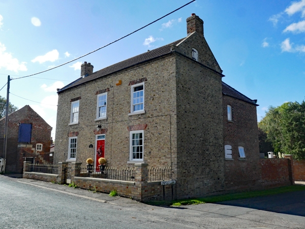
House. Mid-late C18 with C19 addition to rear. Yellow brick in Flemish bond with red rubbed-brick dressings; red brick addition. Concrete tile roof. Rectangular on plan: original L-shaped section with 2-room, central entrance-hall east front and single-room wing to rear left, and later addition in angle to rear right. 2 storeys with attic, 3 bays; symmetrical. C20 4-fielded-panel door beneath plain overlight in architrave beneath flat red brick arch. C19 4-pane sashes in original C18 flush wooden architraves with sills beneath similar flat arches. Stepped and cogged brick eaves cornice. Stone-coped gables with shaped kneelers. Corniced end stacks, that to left rebuilt. Left return: main range has small inserted C19 2-pane sash beneath cambered red brick arch, original attic hatch with board door on strap hinges beneath segmental arch. Lower rear section has original 4- fielded-panel door in architrave beneath red brick flat arch, C19 4-pane ground-floor sash to left, and small casement to first floor in original openings beneath red brick flat arches. Stepped and cogged brick eaves cornice, raised gable, rebuilt end stack. Interior contains open-well staircase with moulded handrail and column-on-vase balusters with square knops, pilastered marble chmney-piece to ground-floor front left room, 6- fielded-panel doors in architraves; not fully inspected. Unoccupied at time of resurvey (April 1987).
Listing NGR: SE8440620792
External links are from the relevant listing authority and, where applicable, Wikidata. Wikidata IDs may be related buildings as well as this specific building. If you want to add or update a link, you will need to do so by editing the Wikidata entry.


Other nearby listed buildings