Approximate Location Map
Large Map »
Latitude: 51.3358 / 51°20'8"N
Longitude: 1.4138 / 1°24'49"E
OS Eastings: 637880
OS Northings: 165168
OS Grid: TR378651
Mapcode National: GBR X0L.48R
Mapcode Global: VHMCW.GP7B
Plus Code: 9F338CP7+8F
Entry Name: Brewery Buildings, Now Depository
Listing Date: 4 February 1988
Grade: II
Source: Historic England
Source ID: 1348497
English Heritage Legacy ID: 171703
ID on this website: 101348497
Location: Ramsgate, Thanet, Kent, CT11
County: Kent
District: Thanet
Civil Parish: Ramsgate
Built-Up Area: Ramsgate
Traditional County: Kent
Lieutenancy Area (Ceremonial County): Kent
Tagged with: Brewery
RAMSGATE CANNON ROAD
TR 3765 SE
(north west side)
8/74 Brewery buildings,
now depository
GV II
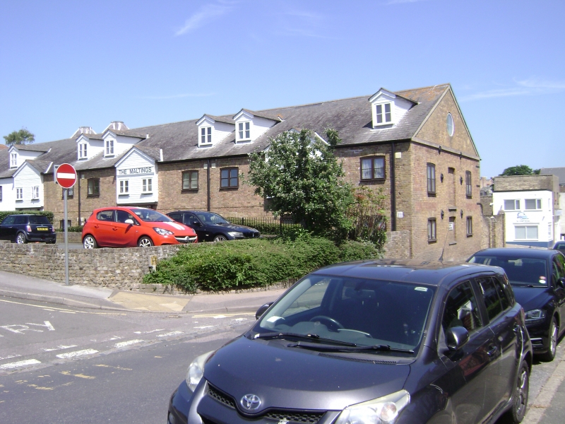
Brewery buildings, now depository. Mid C19. Stock brick and slate
roof. Maltings and oasts. Main range of 2 storeys and loft, with
corbelled cornice. Large weatherboarded hoist housing with barge-
boarded gable, on long brackets. Three segmentally headed windows on
1st floor, 2 horizontally sliding sashes with central wooden casement
with boarded door to right and external wooden staircase. Three
segmentally headed windows with iron grills on ground floor and boarded
door to right. Left return with pedimented gable and blank roundel, and
3 blank window recesses on each floor. Projecting at end right a cross
wing with 2 square plain oasts, with 2 segmentally headed openings high
on each elevation and brick dentil eaves cornice. Large C20 vehicle
doors to left return elevation. Rear elevation with irregular segmentally
headed openings. Interior structure reported unaltered. Originally the
Cannon Brewery, bought out by Tomson and Wootton in 1876, and still in
use as brewery in 1918. (See Busson, Ramsgate, 91; see also Mirams,
Old Ramsgate Pubs, 12).
Listing NGR: TR3788065168
External links are from the relevant listing authority and, where applicable, Wikidata. Wikidata IDs may be related buildings as well as this specific building. If you want to add or update a link, you will need to do so by editing the Wikidata entry.


Other nearby listed buildings
