Approximate Location Map
Large Map »
Latitude: 53.4304 / 53°25'49"N
Longitude: -2.9574 / 2°57'26"W
OS Eastings: 336486
OS Northings: 393049
OS Grid: SJ364930
Mapcode National: GBR 7BD.89
Mapcode Global: WH877.J1YJ
Plus Code: 9C5VC2JV+52
Entry Name: The Arkles Public House
Listing Date: 19 June 1985
Grade: II
Source: Historic England
Source ID: 1356258
English Heritage Legacy ID: 213701
Also known as: Arkles
The Arkles, Liverpool
ID on this website: 101356258
Location: Anfield, Liverpool, Merseyside, L4
County: Liverpool
Electoral Ward/Division: Anfield
Parish: Non Civil Parish
Built-Up Area: Liverpool
Traditional County: Lancashire
Lieutenancy Area (Ceremonial County): Merseyside
Church of England Parish: Walton Breck Christ Church and Holy Trinity
Church of England Diocese: Liverpool
Tagged with: Pub
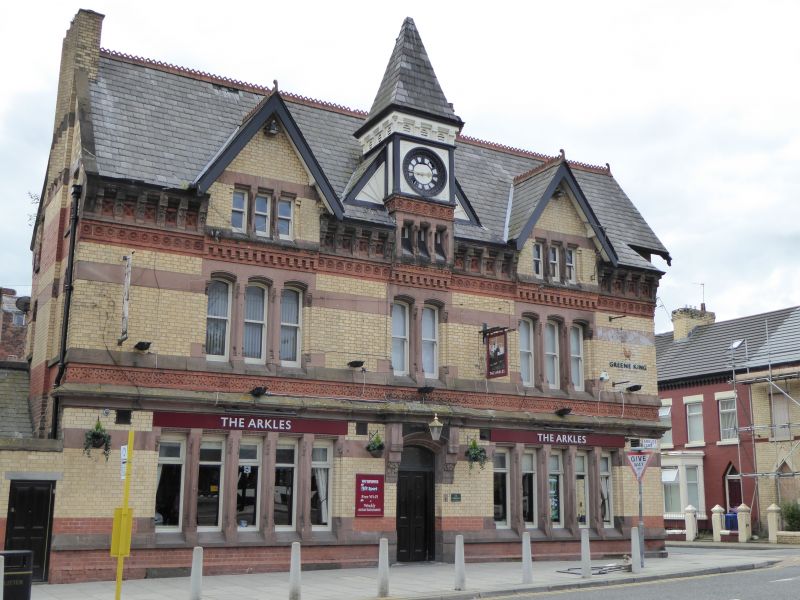
SJ 39 SE ARKLES LANE
L4
4/98 The Arkles
- Public House
- II
Public House. 1880s. Yellow brick with red brick and stone
dressings, slate roof. 2 storeys and attic, 3 x 3 bays.
Ground floor sill band, frieze over ground floor and top
frieze and bracketed cornice; flush stone bands. Windows are
mullioned, those to ground floor of 5 lights, those to 1st
floor of 3:2:3 lights, those to attic of 3 lights, the
central one supports square clock tower and pyramidal roof,
the flanking ones under gables. Entrance has segmental head
and corbelled hood. Right return has 2 projecting bays under
gables. An elaborate example of a public house exploiting a
corner site.
Listing NGR: SJ3648693049
External links are from the relevant listing authority and, where applicable, Wikidata. Wikidata IDs may be related buildings as well as this specific building. If you want to add or update a link, you will need to do so by editing the Wikidata entry.


Other nearby listed buildings
