Latitude: 53.4802 / 53°28'48"N
Longitude: -2.0953 / 2°5'42"W
OS Eastings: 393774
OS Northings: 398169
OS Grid: SJ937981
Mapcode National: GBR FXT6.55
Mapcode Global: WHB9J.SSFC
Plus Code: 9C5VFWJ3+3V
Entry Name: Church of St Mark
Listing Date: 6 February 1986
Grade: II
Source: Historic England
Source ID: 1356419
English Heritage Legacy ID: 212456
Also known as: St Mark's Church, Dukinfield
ID on this website: 101356419
Location: Dukinfield, Tameside, Greater Manchester, SK16
County: Tameside
Electoral Ward/Division: Dukinfield
Parish: Non Civil Parish
Built-Up Area: Dukinfield
Traditional County: Cheshire
Lieutenancy Area (Ceremonial County): Greater Manchester
Church of England Parish: Dukinfield St Mark
Church of England Diocese: Chester
Tagged with: Church building
DUKINFIELD CHURCH STREET SJ 99 NW (west side) 3/1 Church of St. Mark - II
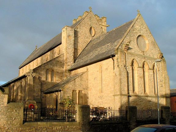
Church. 1848-9. By Joseph Clarke for the Church Commissioners; tower 1880-1 by J. Eaton and Sons. Snecked stone, ashlar dressings and slate roof. Nave with aisles, clerestory, porch and north-west tower; chancel with vestry and organ chamber. 5-bay nave and aisles have paired lancets, weathered buttresses (clasping at corners) and circular clerestory lights. Porch in bay 2. 4-stage tower with angle buttresses, lancet openings, clock faces and a machicolated parapet with stepped merlons and grotesque gargoyles. Coped gables with cross finials. Piers at the east of the nave were formerly terminated in large pinnacles which now form garden features. Interior: nave arcade has alternating round and octagonal piers with moulded capitals and bases. Double-chamfered chancel arch. Scissor-braced roof trusses. Various timber fittings, stained glass and alabaster font.
Listing NGR: SJ9377498169
External links are from the relevant listing authority and, where applicable, Wikidata. Wikidata IDs may be related buildings as well as this specific building. If you want to add or update a link, you will need to do so by editing the Wikidata entry.


Other nearby listed buildings