Approximate Location Map
Large Map »
Latitude: 51.316 / 51°18'57"N
Longitude: 0.8898 / 0°53'23"E
OS Eastings: 601476
OS Northings: 161402
OS Grid: TR014614
Mapcode National: GBR SW3.HR8
Mapcode Global: VHKJW.C5RY
Plus Code: 9F328V8Q+CW
Entry Name: 12, West Street
Listing Date: 29 July 1950
Grade: II
Source: Historic England
Source ID: 1356644
English Heritage Legacy ID: 438531
ID on this website: 101356644
Location: Faversham, Swale, Kent, ME13
County: Kent
District: Swale
Civil Parish: Faversham
Built-Up Area: Faversham
Traditional County: Kent
Lieutenancy Area (Ceremonial County): Kent
Tagged with: Building
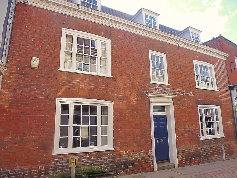
WEST STREET
1.
ll03 (South Side)
------------
No 12
Tli 0161 SW 2/110 29.7.50.
II GV
2.
C18 front to a C17 timber-framed core. 2 storeys. 3 windows. 3 dormers.
Mathematical tiles. Wooden modillion eaves cornice. Slate roof. Glazing
bars intact. Doorway in moulded arohitrave surround with projecting
cornice, rectangular fanlight and door of 6 fielded panels. Photograph in
NMR.
Nos 1 and 2 and Nos 4 to 12 (oonsec) form a group with Nos l4 to l6 (consec)
The Market Place.
Listing NGR: TR0147661402
External links are from the relevant listing authority and, where applicable, Wikidata. Wikidata IDs may be related buildings as well as this specific building. If you want to add or update a link, you will need to do so by editing the Wikidata entry.


Other nearby listed buildings
