Latitude: 51.5001 / 51°30'0"N
Longitude: -0.151 / 0°9'3"W
OS Eastings: 528439
OS Northings: 179532
OS Grid: TQ284795
Mapcode National: GBR BJ.8D
Mapcode Global: VHGQZ.BKJB
Plus Code: 9C3XGR2X+3J
Entry Name: 33-37, Chapel Street SW1
Listing Date: 1 December 1987
Grade: II
Source: Historic England
Source ID: 1357290
English Heritage Legacy ID: 209083
ID on this website: 101357290
Location: Hyde Park Corner, Westminster, London, SW1X
County: London
District: City of Westminster
Electoral Ward/Division: Knightsbridge and Belgravia
Parish: Non Civil Parish
Built-Up Area: City of Westminster
Traditional County: Middlesex
Lieutenancy Area (Ceremonial County): Greater London
Church of England Parish: St Paul Knightsbridge
Church of England Diocese: London
Tagged with: Building
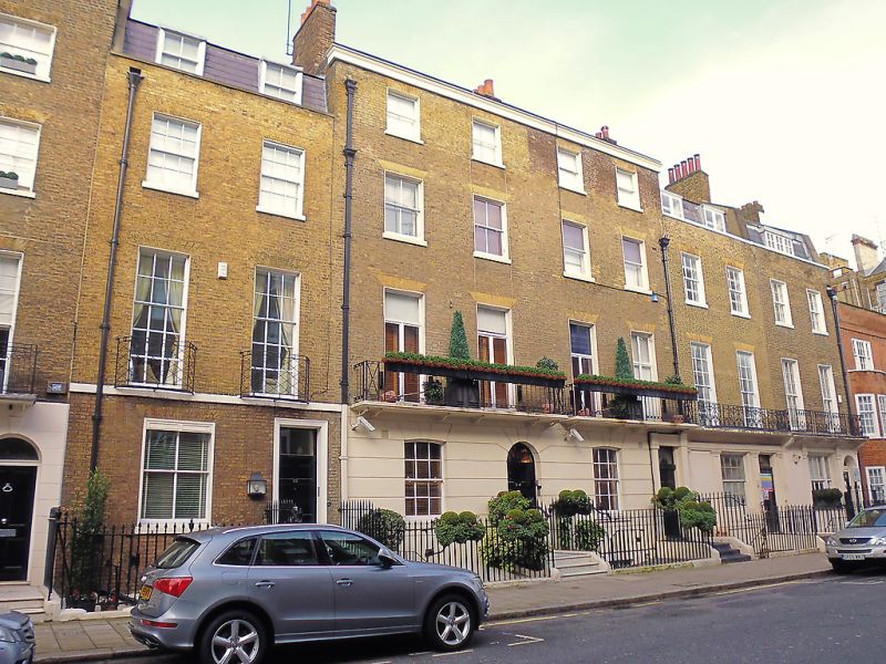
TQ 2879 NW CITY OF WESTMINSTER CHAPEL STREET, SW1
88/52
Nos 33 to 37 (consec)
GV II
Terraced houses. Early C19. Brick. Slate mansard attics to Nos 33, 36 and 37.
3 storeys and basement (Nos 34 and 35 of 4 full storeys). Each house 2 windows
wide. Stucco to ground floor except No 33; channelling to nos 34 and 35.
Altered ground floor windows to Nos 36 and 37. Doorways mainly square headed
(arched to Nos 34 and 37). First floor balconies, various designs (probably C20
to Nos 34 and 35). Square gauged headed sashed windows, glazing bars except to
Nos 34 and 35 which have French casements to first floor and stucco cornice.
Wrought iron area railings.
Listing NGR: TQ2843979532
External links are from the relevant listing authority and, where applicable, Wikidata. Wikidata IDs may be related buildings as well as this specific building. If you want to add or update a link, you will need to do so by editing the Wikidata entry.


Other nearby listed buildings