Latitude: 53.4069 / 53°24'24"N
Longitude: -2.9849 / 2°59'5"W
OS Eastings: 334621
OS Northings: 390457
OS Grid: SJ346904
Mapcode National: GBR 74N.9Q
Mapcode Global: WH877.3MWL
Plus Code: 9C5VC248+P2
Entry Name: 19-23, SIR THOMAS STREET (See details for further address information)
Listing Date: 19 June 1985
Grade: II
Source: Historic England
Source ID: 1360240
English Heritage Legacy ID: 359527
ID on this website: 101360240
Location: Liverpool, Merseyside, L1
County: Liverpool
Electoral Ward/Division: Central
Parish: Non Civil Parish
Built-Up Area: Liverpool
Traditional County: Lancashire
Lieutenancy Area (Ceremonial County): Merseyside
Church of England Parish: Liverpool Our Lady and St Nicholas
Church of England Diocese: Liverpool
Tagged with: Building
SJ 3490 SE SIR THOMAS STREET L1
53/1156 Nos. 19-23 (odd) -
- II
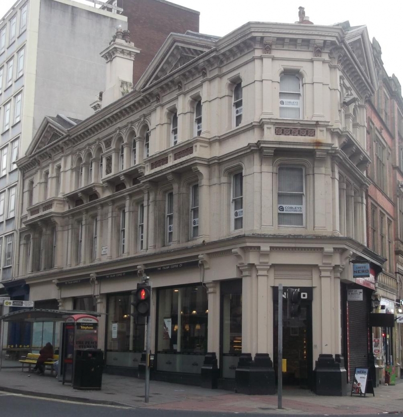
Includes No. 45 Whitechapel. Shops. 1860's. Stucco and slate roof. 3 storeys and 6 bays, canted corner bay, 2 bays to Whitechapel. C20 ground floor with remaining entrance in 1st bay. 2nd and 5th bays break forward. 1st floor 1:2:2:2:2:1 windows, those to centre bays with pilasters. All windows are sashed without glazing 'bars. Cornice. 2nd floor centre bays have windows of 3 round headed lights, carved panel between. Wide, bracketed sills with apron panels. Other bays have shouldered arched windows, those to 2nd and 5th bays with balconies and with pediments over. Bracketed cornice and central stack with cornice.
Listing NGR: SJ3462190457
External links are from the relevant listing authority and, where applicable, Wikidata. Wikidata IDs may be related buildings as well as this specific building. If you want to add or update a link, you will need to do so by editing the Wikidata entry.


Other nearby listed buildings