Approximate Location Map
Large Map »
Latitude: 51.2114 / 51°12'41"N
Longitude: 0.7959 / 0°47'45"E
OS Eastings: 595382
OS Northings: 149514
OS Grid: TQ953495
Mapcode National: GBR RVT.XR3
Mapcode Global: VHKK6.RT46
Plus Code: 9F326Q6W+H9
Entry Name: Forge House
Listing Date: 10 October 1980
Grade: II
Source: Historic England
Source ID: 1362984
English Heritage Legacy ID: 180763
ID on this website: 101362984
Location: Charing, Ashford, Kent, TN27
County: Kent
District: Ashford
Civil Parish: Charing
Built-Up Area: Charing
Traditional County: Kent
Lieutenancy Area (Ceremonial County): Kent
Tagged with: House
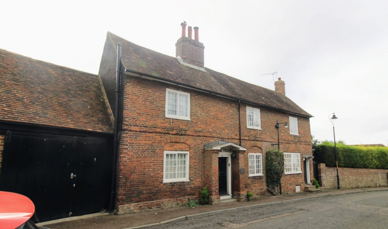
1.
5272 CHARING HIGH STREET
(east side)
No 80 and
Forge House
TQ 9549 22/12
II
2.
Two C18 cottages. Two storeys and basement red brick. Tiled roof. Three
casement windows. Stringcourse. Forge House has a door of 4 moulded panels
in a brick porch. No 80 has a doorcase with flat hood over and brackets.
Brick relieving arches to ground floor windows.
Listing NGR: TQ9538249514
External links are from the relevant listing authority and, where applicable, Wikidata. Wikidata IDs may be related buildings as well as this specific building. If you want to add or update a link, you will need to do so by editing the Wikidata entry.


Other nearby listed buildings
