Approximate Location Map
Large Map »
Latitude: 52.2423 / 52°14'32"N
Longitude: 0.712 / 0°42'43"E
OS Eastings: 585260
OS Northings: 263919
OS Grid: TL852639
Mapcode National: GBR QF0.DVC
Mapcode Global: VHKD4.9W8Y
Plus Code: 9F426PR6+WR
Entry Name: The Black Boy Public House
Listing Date: 12 July 1972
Last Amended: 30 October 1997
Grade: II
Source: Historic England
Source ID: 1363705
English Heritage Legacy ID: 466864
Also known as: The Black Boy, Bury St. Edmunds
The Black Boy
ID on this website: 101363705
Location: Bury St Edmunds, West Suffolk, IP33
County: Suffolk
District: West Suffolk
Civil Parish: Bury St Edmunds
Built-Up Area: Bury St Edmunds
Traditional County: Suffolk
Lieutenancy Area (Ceremonial County): Suffolk
Church of England Parish: Bury St Edmunds St Mary
Church of England Diocese: St.Edmundsbury and Ipswich
Tagged with: Pub
BURY ST EDMUNDS
TL8563NW GUILDHALL STREET
639-1/15/391 (West side)
12/07/72 No.69
The Black Boy Public House
(Formerly Listed as:
GUILDHALL STREET
(West side)
No.69
Black Boy Inn)
GV II
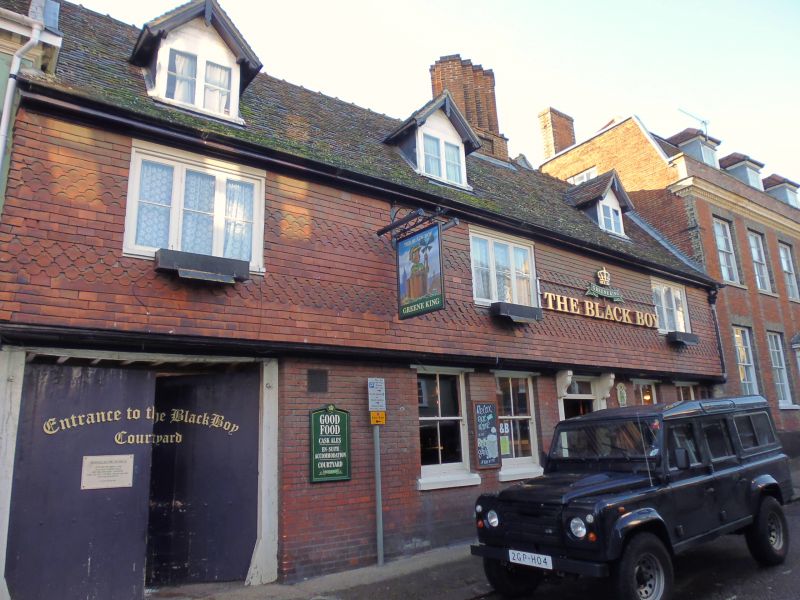
Public house. C17, with C19 and C20 alterations.
Timber-framed; jettied along the street frontage; faced in C19
red brick on the ground storey and with tile-hanging in
alternate bands of plain and scalloped tiles to the 1st
storey. Plaintiled roof.
EXTERIOR: 2 storeys, attics and cellar. An internal
chimney-stack has 4 saw-tooth shafts on a rectangular base
with a front panel. 3 windows to the 1st storey: all 3-light
early C20 casements with a single horizontal glazing bar in a
heavy flush frame. 4 sash windows to the ground storey, all
with a single vertical glazing bar in plain reveals with
moulded heads below the jetty. 3 gabled dormers with plain
bargeboards and hanging finials have single bar 2-light
casement windows. Entrance door with 2 leaves in a plain wood
surround with a rectangular fanlight flanked by 2 shaped
brackets below the jetty. A small timber-framed wing at the
rear and a larger extension of 1935.
INTERIOR: modernised brick-lined cellar. Frame in 4 bays. Most
internal timbers are covered; chamfered main beams only are
exposed on the ground storey. The bay at the south end is an
open carriage entrance with an exposed ceiling: chamfered main
beam with triangle stops, joists set flat, widely spaced.
Listing NGR: TL8526063919
External links are from the relevant listing authority and, where applicable, Wikidata. Wikidata IDs may be related buildings as well as this specific building. If you want to add or update a link, you will need to do so by editing the Wikidata entry.


Other nearby listed buildings
